Fonte Aleixo
| Fonte Aleixo | |
|---|---|

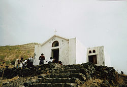
Church of Fonte Aleixo
|
|
| Coordinates: 14°50′53″N 24°21′22″W / 14.848°N 24.356°WCoordinates: 14°50′53″N 24°21′22″W / 14.848°N 24.356°W | |
| Country | Cape Verde |
| Island | Fogo |
| Municipality | Santa Catarina do Fogo |
| Civil parish | Santa Catarina do Fogo |
| Population (2010) | |
| • Total | 401 |
Fonte Aleixo is a settlement in the southern part of the island of Fogo, Cape Verde. It is situated 16 km southeast of the island capital São Filipe and is connected with the Fogo Circular road connecting with Cova Figueira. and also connects with the lesser road north to Achada Furna and Chã das Caldeiras (EN3-FG05). Its 2010 population was 401. A few kilometers south has the island's southernmost point. Other nearby places include Monte Vermelho to the east and Salto to the west.
The village's etymology is named after a spring located nearby.
Its climate is about a degree warmer than Achada Furna as it is in a lower elevation than the town but higher than the Atlantic.
Around 73,000 BC or 75,000 years ago, the area was formed as part of the interior of the earlier Fogo Mountain, the eastern half collapsed and with some erosion and lava flow over the centuries, thouth not as much as in the east and some small volcanoes, it would form the current landscape. From that point hundreds of meters west of modern day Fonte Aleixo, it formed the line of where it collapsed, there, not much had collapsed in the area.
During the 2014-15 eruption of Fogo, the village was partly covered with volcanic clouds but in early December, it was escaped.
...
Wikipedia

