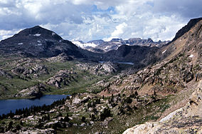
Absaroka-Beartooth Wilderness
| Absaroka-Beartooth Wilderness | |
|---|---|
|
IUCN category Ib (wilderness area)
|
|
 |
|
| Location | Montana / Wyoming, USA |
| Nearest city | Red Lodge, MT |
| Coordinates | 45°6′N 109°56′W / 45.100°N 109.933°WCoordinates: 45°6′N 109°56′W / 45.100°N 109.933°W |
| Area | 944,000 acres (3,820 km2) |
| Established | 1978 |
| Governing body | U.S. Forest Service |
Absaroka-Beartooth Wilderness was created from existing National Forest lands in 1978 and is located in Montana and Wyoming, United States. The wilderness is partly in Gallatin, Custer and Shoshone National Forests and is composed of 944,000 acres (3,820 km2). The wilderness encompasses two distinct mountain ranges, namely the Beartooth and Absaroka ranges. These ranges are completely distinct geologically speaking with the Absarokas composed primarily of volcanic (or extrusive) and metamorphic rock, while the Beartooths are made up almost entirely of granitic rocks. The Absarokas are noted for their dark and craggy appearance, lush and heavily forested valleys and abundant wildlife. The highest peak in the range, located in Wyoming, is Francs Peak at 13,153 feet (4,009 m). The Beartooths are more with huge treeless plateaus and the highest peak in the state of Montana (Granite Peak 12,799 feet (3,901 m)). The wilderness contains 30 peaks over 12,000 feet (3,700 m). The wilderness is an integral part of the 20-million-acre (81,000 km2) Greater Yellowstone Ecosystem and borders Yellowstone National Park.
Wilderness areas do not allow motorized or mechanical equipment including bicycles. Although camping and fishing are allowed with proper permit, no roads or buildings are constructed and there is also no logging or mining, in compliance with the 1964 Wilderness Act. Wilderness areas within National Forests and Bureau of Land Management areas also allow hunting in season.
...
Wikipedia

