Aberdeenshire
| Aberdeenshire Aiberdeenshire Siorrachd Obar Dheathain |
|
|---|---|
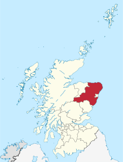
 Aberdeenshire within Scotland |
|
| Coordinates: 57°9′3.6″N 2°7′22.8″W / 57.151000°N 2.123000°WCoordinates: 57°9′3.6″N 2°7′22.8″W / 57.151000°N 2.123000°W | |
| Admin HQ | Aberdeen |
| Government | |
| • Body | Aberdeenshire Council |
| • Control | SNP + Progressive Alliance (2 Lab + 1 Independent) |
| • MPs |
|
| • MSPs |
|
| Area | |
| • Total | 2,437 sq mi (6,313 km2) |
| Area rank | Ranked 4th |
| Population (mid-2015 est.) | |
| • Total | 262,000 |
| • Rank | Ranked 6th |
| • Density | 110/sq mi (41/km2) |
| ONS code | S12000034 |
| ISO 3166 code | GB-ABD |
| Website | www |
Aberdeenshire (Scottish Gaelic: Siorrachd Obar Dheathain) is one of the 32 council areas of Scotland.
It takes its name from the old County of Aberdeen which had substantially different boundaries. Modern Aberdeenshire includes all of what was once Kincardineshire, as well as part of Banffshire. The old boundaries are still officially used for a few purposes, namely land registration and lieutenancy.
Aberdeenshire Council is headquartered at Woodhill House, in Aberdeen, making it the only Scottish council whose headquarters are located outside its jurisdiction. Aberdeen itself forms a different council area (Aberdeen City). Aberdeenshire borders onto Angus and Perth and Kinross to the south, Highland and Moray to the west and Aberdeen City to the east.
Traditionally, it has been economically dependent upon the primary sector (agriculture, fishing, and forestry) and related processing industries. Over the last 40 years, the development of the oil and gas industry and associated service sector has broadened Aberdeenshire's economic base, and contributed to a rapid population growth of some 50% since 1975. Its land represents 8% of Scotland's overall territory. It covers an area of 6,313 square kilometres (2,437 sq mi).
Aberdeenshire has a rich prehistoric and historic heritage. It is the locus of a large number of Neolithic and Bronze Age archaeological sites, including Longman Hill, Kempstone Hill, Catto Long Barrow and Cairn Lee. The area was settled in the Bronze Age by the Beaker culture, who arrived from the south around 2000-1800 BC. Stone circles and cairns were constructed predominantly in this era. In the Iron Age, hill forts were built. Around the 1st century AD, the Taexali people, who have left little history, were believed to have resided along the coast. The Picts were the next documented inhabitants of the area, and were no later than 800-900 AD. The Romans also were in the area during this period, as they left signs at Kintore. Christianity influenced the inhabitants early on, and there were Celtic monasteries at Old Deer and Monymusk.
...
Wikipedia
