Aalsmeer
| Aalsmeer | |||
|---|---|---|---|
| Municipality | |||

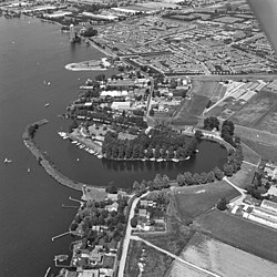
Aerial photo of Aalsmeer in 1977
|
|||
|
|||
| Nickname(s): Flower capital of the world | |||
 Location in North Holland |
|||
| Coordinates: 52°16′N 4°45′E / 52.267°N 4.750°ECoordinates: 52°16′N 4°45′E / 52.267°N 4.750°E | |||
| Country | Netherlands | ||
| Province | North Holland | ||
| Government | |||
| • Body | Municipal council | ||
| • Mayor | Jeroen Nobel (PvdA) | ||
| • Aldermen |
List of aldermen
|
||
| Area | |||
| • Total | 32.29 km2 (12.47 sq mi) | ||
| • Land | 20.44 km2 (7.89 sq mi) | ||
| • Water | 11.85 km2 (4.58 sq mi) | ||
| Elevation | -0.1 m (−0.3 ft) | ||
| Population (February 2017) | |||
| • Total | 30,878 | ||
| • Density | 1,511/km2 (3,910/sq mi) | ||
| Demonym(s) | Aalsmeerder | ||
| Time zone | CET (UTC+1) | ||
| • Summer (DST) | CEST (UTC+2) | ||
| Postcode | 1430–1433 | ||
| Area code | 0297 | ||
| Website | www |
||
Aalsmeer (![]() pronunciation ) is a municipality and a town in the Netherlands, in the province of North Holland. Its name is derived from the Dutch for eel (aal) and lake (meer). Aalsmeer is bordered by the Westeinderplassen lake, the largest open water of the Randstad, and the Ringvaart Canal. The town is located 13 km (8 mi) southwest of Amsterdam.
pronunciation ) is a municipality and a town in the Netherlands, in the province of North Holland. Its name is derived from the Dutch for eel (aal) and lake (meer). Aalsmeer is bordered by the Westeinderplassen lake, the largest open water of the Randstad, and the Ringvaart Canal. The town is located 13 km (8 mi) southwest of Amsterdam.
The town is sometimes referred to as the flower capital of the world, as the largest flower auction in the world is based in Aalsmeer, along with numerous nurseries and an experimental stations for floriculture
The municipality of Aalsmeer consists of the following cities, towns, and villages: Aalsmeer, Kudelstaart, Oosteinde, as well as the hamlet Calslagen.
Aalsmeer is located on the border of the former Haarlem Lake. The older portion of town is built on peat, and is surrounded by polders. The polders consist of loamy soil and are 9–15 feet (2.7–4.6 m) below sea level.
Aalsmeer is first referenced in a document from 1133 in which it is called "Alsmar" and is granted to the Abbey of Rijnsburg. Diederik VII van Kleef confirmed this grant in an act in 1199. The area was then a wilderness with alders and willow forests.
...
Wikipedia


