1960 Pacific typhoon season
| 1960 Pacific typhoon season |
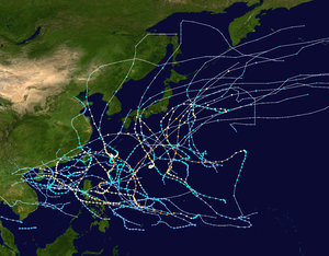
Season summary map
|
| Seasonal boundaries |
| First system formed |
January 30, 1960 |
| Last system dissipated |
December 20, 1960 |
| Strongest storm |
|
| Name |
Shirley |
| • Maximum winds |
250 km/h (155 mph) |
| • Lowest pressure |
910 hPa (mbar) |
| Seasonal statistics |
| Total depressions |
39 |
| Total storms |
30 |
| Typhoons |
19 |
| Super typhoons |
2 |
| Total fatalities |
>2,869 |
| Total damage |
At least $69 million (1960 USD) |
| Related articles |
|
|
Pacific typhoon seasons
1958, 1959, 1960, 1961, 1962
|
| Tropical depression (JMA) |
| Tropical depression (SSHWS) |
|
|
| Duration |
January 30 – February 3 |
| Peak intensity |
55 km/h (35 mph) (1-min) 1000 hPa (mbar) |
| Tropical depression (JMA) |
| Tropical depression (SSHWS) |
|
|
| Duration |
March 7 – March 9 |
| Peak intensity |
45 km/h (30 mph) (1-min) 1004 hPa (mbar) |
| Tropical Storm (JMA) |
| Category 1 typhoon (SSHWS) |
|
|
| Duration |
April 21 – April 27 |
| Peak intensity |
140 km/h (85 mph) (1-min) 990 hPa (mbar) |
| Typhoon (JMA) |
| Tropical Storm (SSHWS) |
|
|
| Duration |
May 27 – June 2 |
| Peak intensity |
85 km/h (50 mph) (1-min) 985 hPa (mbar) |
| Typhoon (JMA) |
| Category 1 typhoon (SSHWS) |
|
|
| Duration |
June 2 – June 11 |
| Peak intensity |
150 km/h (90 mph) (1-min) 980 hPa (mbar) |
| Typhoon (JMA) |
| Tropical Storm (SSHWS) |
|
|
| Duration |
June 2 – June 11 |
| Peak intensity |
110 km/h (70 mph) (1-min) 985 hPa (mbar) |
| Typhoon (JMA) |
| Category 4 typhoon (SSHWS) |
|
|
| Duration |
June 21 – July 1 |
| Peak intensity |
230 km/h (145 mph) (1-min) 950 hPa (mbar) |
| Typhoon (JMA) |
| Category 4 typhoon (SSHWS) |
|
|
| Duration |
July 17 – July 28 |
| Peak intensity |
215 km/h (130 mph) (1-min) 950 hPa (mbar) |
| Tropical Storm (JMA) |
| Tropical Storm (SSHWS) |
|
|
| Duration |
July 24 – July 29 |
| Peak intensity |
75 km/h (45 mph) (1-min) 1000 hPa (mbar) |
The 1960 Pacific typhoon season had no official bounds; it ran year-round in 1960, but most tropical cyclones tend to form in the northwestern Pacific Ocean between June and December. These dates conventionally delimit the period of each year when most tropical cyclones form in the northwestern Pacific Ocean.
The scope of this article is limited to the Pacific Ocean, north of the equator and west of the international date line. Storms that form east of the date line and north of the equator are called hurricanes; see 1960 Pacific hurricane season. Tropical storms formed in the entire west Pacific basin were assigned a name by the Joint Typhoon Warning Center. Tropical depressions in this basin had the "W" suffix added to their number.
An area of disturbed weather in the Philippine Sea moved westward, and organized into a tropical depression on April 22. It moved northwestward through the Philippines, strengthening quickly to a typhoon on the 24th due to its small size. Karen turned to the northeast, and in spite of favorable conditions, rapidly weakened until dissipation on the 26th. Karen left 56 dead in the Philippines, left 7,000 homeless, and caused $2 million (1960 USD) in crop and property damage.
Lucille was identified as a weak tropical depression on May 25 to the east of the Philippines. Tracking northwestward, the system failed to develop and warnings on it were discontinued on May 27. At the same time, a second system began organizing along the west coast of Luzon. The two systems ultimately merged into one over the Philippines between May 28 and 29. Now tracking northeastward, the system re-intensified and became a tropical storm on May 30. Lucille attained its peak intensity later that day with winds of 85 km/h (50 mph). As it accelerated over open waters, the system brushed the islands of Iwo Jima and Chichi-jima before transitioning into an extratropical cyclone on June 1. The remnants of Lucille were last noted on June 4 near the International Date Line.
Between May 27 and 29, heavy rains fell across much of Luzon as Lucille developed. These rains, amounting to 406 mm (16 in) in the suburbs of Manila, triggered destructive floods that left some areas under 4.6 m (15 ft) of water. The worst of the floods took place during the overnight hours of May 28 to 29. During that time, hundreds of homes were swept away and an estimated 300–500 people, including at least 80 children, were killed. Monetary losses from the floods exceeded $2 million.
...
Wikipedia


