1938 Hurricane
| Category 5 major hurricane (SSHWS/NWS) | |

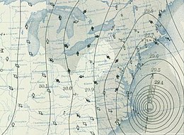
Weather map from September 21 depicting the storm off the Mid-Atlantic coast
|
|
| Formed | September 9, 1938 |
|---|---|
| Dissipated | September 23, 1938 |
| (Extratropical after September 22) | |
| Highest winds |
1-minute sustained: 160 mph (260 km/h) |
| Lowest pressure | < 940 mbar (hPa); 27.76 inHg |
| Fatalities | 682 to 800 direct |
| Damage | $306 million (1938 USD) |
| Areas affected | Southeastern United States, Northeastern United States (particularly Connecticut, New York, Rhode Island, and Massachusetts), southwestern Quebec |
| Part of the 1938 Atlantic hurricane season | |
The 1938 New England Hurricane (also referred to as the Great New England Hurricane and Long Island Express) was one of the deadliest and most destructive tropical cyclones to strike Long Island, New York and New England. The storm formed near the coast of Africa on September 9, becoming a Category 5 hurricane on the Saffir-Simpson Hurricane Scale before making landfall as a Category 3 hurricane on Long Island on September 21. It is estimated that the hurricane killed 682 people, damaged or destroyed more than 57,000 homes, and caused property losses estimated at US$306 million ($4.7 billion in 2017). Damaged trees and buildings were still seen in the affected areas as late as 1951. It remains the most powerful and deadliest hurricane in recorded New England history, eclipsed in landfall intensity perhaps only by the Great Colonial Hurricane of 1635.
The storm was first analyzed by ship data south of the Cape Verde Islands on September 9. Over the next ten days, it steadily gathered strength and slowly tracked to the west-northwest; it is estimated to have reached Category 5 intensity by September 20, while centered east of the Bahamas. It then veered northward in response to a deep trough over Appalachia, sparing the Bahamas, Florida, the Carolinas, and the Mid-Atlantic states. At the same time, a high pressure system was centered north of Bermuda, preventing the hurricane from making an eastward turn out to sea.
Thus, the hurricane was effectively squeezed to the north between the two weather systems. This caused the storm's forward speed to increase substantially late on September 20, ultimately reaching 70 mph, the highest forward velocity ever recorded in the annals of hurricanes. This extreme forward motion was in the same general direction as the winds on the eastern side of the storm as it proceeded north; this, in turn, caused the wind speed to be far higher in areas east of the storm's eye than would be the case with a hurricane of more typical forward speed.
...
Wikipedia
