1899 San Ciriaco hurricane
| Category 4 major hurricane (SSHWS/NWS) | |

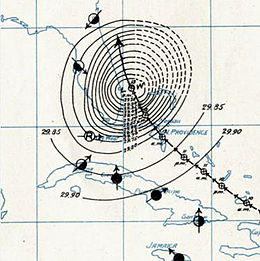
Surface Weather Analysis of Hurricane San Ciriaco on August 13, 1899.
|
|
| Formed | August 3, 1899 |
|---|---|
| Dissipated | September 12, 1899 |
| (Extratropical after September 4, 1899) | |
| Highest winds |
1-minute sustained: 150 mph (240 km/h) |
| Lowest pressure | 930 mbar (hPa); 27.46 inHg |
| Fatalities | 3433 direct |
| Damage | $20 million (1899 USD) |
| Areas affected | Leeward Islands, Puerto Rico, Hispaniola, Turks and Caicos Islands, Cuba, Bahamas, East Coast of the United States (Landfall in North Carolina), Atlantic Canada, Azores |
| Part of the 1899 Atlantic hurricane season | |
1899 San Ciriaco hurricane, also known as the 1899 Puerto Rico Hurricane, was the longest-lived Atlantic hurricane on record. The third tropical cyclone and first major hurricane of the season, this storm was first observed southwest of Cape Verde on August 3. It slowly strengthened while heading steadily west-northwestward across the Atlantic Ocean and reached hurricane status by late on August 5. During the following 48 hours, it deepened further, reaching Category 4 on the modern day Saffir–Simpson hurricane wind scale (SSHWS) before crossing the Leeward Islands on August 7. Later that day, the storm peaked winds of 150 mph (240 km/h). The storm weakened slightly before making landfall in Guayama, Puerto Rico with winds of 140 mph (220 km/h) on August 8. Several hours later, it emerged into the southwestern Atlantic as a Category 3 hurricane. The system paralleled the north coast of Dominican Republic and then crossed the Bahamas, striking several islands. Thereafter, it began heading northward on August 14, while centered east of Florida. Early on the following day, the storm re-curved northeastward and appeared to be heading out to sea. However, by August 17, it turned back to the northwest and made landfall near Hatteras, North Carolina early on the following day. No stronger hurricane has made landfall on the Outer Banks since San Ciriaco.
The storm weakened after moving inland and fell to Category 1 intensity by 1200 UTC on August 18. Later that day, the storm re-emerged into the Atlantic. Now heading northeastward, it continued weakening, but maintained Category 1 intensity. By late on August 20, the storm curved eastward over the northwestern Atlantic. It also began losing tropical characteristics and transitioned into an extratropical cyclone at 0000 UTC on August 22, while located about 325 miles (525 km) south of Sable Island. However, after four days, the system regenerated into a tropical storm while located about 695 miles (1,120 km) west-southwest of Flores Island in the Azores on August 26. It moved slowly north-northwestward, until curving to the east on August 29. Between August 26 and September 1, the storm did not differentiate in intensity, but began re-strengthening while turning southeastward on September 2. Early on the following day, the storm again reached hurricane intensity. It curved northeastward and passed through the Azores on September 3, shortly before transitioning into an extratropical cyclone.
...
Wikipedia
