1871 Atlantic hurricane season
| 1871 Atlantic hurricane season |
Season summary map
|
| Seasonal boundaries |
| First system formed |
June 1, 1871 |
| Last system dissipated |
October 13, 1871 |
| Strongest storm |
|
| Name |
Three |
| • Maximum winds |
115 mph (185 km/h) |
| • Lowest pressure |
952 mbar (hPa; 28.11 inHg) |
| Seasonal statistics |
| Total storms |
8 |
Major hurricanes
(Cat. 3+) |
2 |
| Total fatalities |
30+ |
| Total damage |
Unknown |
|
|
Atlantic hurricane seasons
1869, 1870, 1871, 1872, 1873
|
| Tropical storm (SSHWS) |
|
|
| Duration |
June 1 – June 5 |
| Peak intensity |
60 mph (95 km/h) (1-min) 999 mbar (hPa) |
| Tropical storm (SSHWS) |
|
|
| Duration |
June 8 – June 10 |
| Peak intensity |
60 mph (95 km/h) (1-min) Unknown mbar (hPa) |
| Category 3 hurricane (SSHWS) |
|
|
| Duration |
August 14 – August 23 |
| Peak intensity |
115 mph (185 km/h) (1-min) 952 mbar (hPa) |
| Category 3 hurricane (SSHWS) |
|
|
| Duration |
August 17 – August 30 |
| Peak intensity |
115 mph (185 km/h) (1-min) 962 mbar (hPa) |
| Category 2 hurricane (SSHWS) |
|
|
| Duration |
August 30 – September 2 |
| Peak intensity |
105 mph (165 km/h) (1-min) Unknown mbar (hPa) |
| Category 1 hurricane (SSHWS) |
|
|
| Duration |
September 5 – September 8 |
| Peak intensity |
80 mph (130 km/h) (1-min) 985 mbar (hPa) |
| Category 1 hurricane (SSHWS) |
|
|
| Duration |
September 30 – October 7 |
| Peak intensity |
80 mph (130 km/h) (1-min) Unknown mbar (hPa) |
| Category 1 hurricane (SSHWS) |
|
|
| Duration |
October 10 – October 13 |
| Peak intensity |
80 mph (130 km/h) (1-min) Unknown mbar (hPa) |
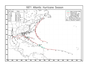
The 1871 Atlantic hurricane season lasted from mid-summer to late-fall. Records show that 1871 featured two tropical storms, four hurricanes and two major hurricanes (Category 3+). However, in the absence of modern satellite and other remote-sensing technologies, only storms that affected populated land areas or encountered ships at sea were recorded, so the actual total could be higher. An undercount bias of zero to six tropical cyclones per year between 1851 and 1885 and zero to four per year between 1886 and 1910 has been estimated. Of the known 1871 cyclones, both Hurricane Five and Hurricane Eight were first documented in 1995 by Jose Fernandez-Partagas and Henry Diaz, who also proposed large changes to the known tracks of Hurricane Three and of Hurricane Four. Further analysis, in 2008, extended the duration of both Hurricane Three and Hurricane Seven, by one day each.
The Atlantic hurricane database (HURDAT) recognizes eight tropical cyclones for the 1871 season. Two were tropical storms and six were hurricanes, with winds of 75 mph (119 km/h) or greater.Tropical Storm One traveled from south of Florida on June 1 to make landfall near Houston, Texas before dissipating further inland. The second tropical storm of the season also made landfall near Houston. Both storms caused considerable damage in Galveston and brought flooding to New Orleans. The third cyclone of the season, and the first hurricane, traveled west from the Bahamas to make landfall in central Florida.It passed through Florida, Georgia and South Carolina and out into the Atlantic.There it looped back and made landfall in Georgia as a tropical storm.Hurricane Four, the second hurricane of the season, started as a tropical storm west of Cape Verde.It crossed the Atlantic to make landfall, first in the Lesser Antilles,then in the Bahamas and then Florida before crossing the Florida peninsula into the Atlantic.Hurricane Five was a Category 2 hurricane,active between August 30 and September 2, that did not make landfall anywhere.Hurricane Six was a Category one hurricane that traveled from the Gulf of Mexico across Florida between September 5 and September 8.Hurricane Seven developed from a tropical storm, which was first seen in the Bay of Campeche on September 30.It strengthened to a Category 1 hurricane as it traveled off the Texas coast but weakened back to a tropical storm before crossing the Florida peninsula.This cyclone was responsible for numerous shipwrecks.Hurricane Eight, the last cyclone of the season was first seen as a Category 1 hurricane on October 10, north-east of the British Virgin Islands.The hurricane traveled as far north as Nova Scotia before dissipating on October 13.
A strong, 50 mph (80 km/h) tropical storm was first observed south of Florida on June 1. The storm traversed through the Gulf of Mexico before making landfall near Houston, Texas as a tropical storm on June 4, where a minimum pressure of 999 mbar was measured. A station in Galveston, Texas recorded 3.95 inches (100 mm) of rain during a 14 minute time span on June 4. Galveston was partially flooded with some railroads and buildings washed away. One vessel, the steamship "Alabama" was thrown ashore at Galveston,while another,the "Virginia Dare" grounded on an offshore sandbar there. Extremely heavy rains associated with this cyclone also caused flooding in New Orleans. The New York Times,on June 6,reported that five hundred blocks of the city were submerged. Eventually the storm dissipated in present-day Oklahoma.
...
Wikipedia


