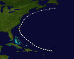
1867 Atlantic hurricane season
| 1867 Atlantic hurricane season |

Season summary map
|
| Seasonal boundaries |
| First system formed |
June 21, 1867 |
| Last system dissipated |
October 31, 1867 |
| Strongest storm |
|
| Name |
Nine |
| • Maximum winds |
130 mph (205 km/h) |
| • Lowest pressure |
952 mbar (hPa; 28.11 inHg) |
| Seasonal statistics |
| Total storms |
9 |
| Hurricanes |
6 |
Major hurricanes
(Cat. 3+) |
1 |
| Total fatalities |
811+ |
| Total damage |
At least $1 million (1867 USD) |
|
|
Atlantic hurricane seasons
1865, 1866, 1867, 1868, 1869. |
| Category 1 hurricane (SSHWS) |
|
|
| Duration |
June 21 – June 23 |
| Peak intensity |
80 mph (130 km/h) (1-min) 985 mbar (hPa) |
| Category 2 hurricane (SSHWS) |
|
|
| Duration |
July 28 – August 3 |
| Peak intensity |
105 mph (165 km/h) (1-min) 969 mbar (hPa) |
| Category 2 hurricane (SSHWS) |
|
|
| Duration |
August 2 – August 2 |
| Peak intensity |
105 mph (165 km/h) (1-min) |
| Category 1 hurricane (SSHWS) |
|
|
| Duration |
August 31 – September 3 |
| Peak intensity |
80 mph (130 km/h) (1-min) |
| Tropical storm (SSHWS) |
|
|
| Duration |
September 8 – September 8 |
| Peak intensity |
60 mph (95 km/h) (1-min) |
| Category 2 hurricane (SSHWS) |
|
|
| Duration |
September 29 – October 1 |
| Peak intensity |
105 mph (165 km/h) (1-min) |
| Category 2 hurricane (SSHWS) |
|
|
| Duration |
October 2 – October 9 |
| Peak intensity |
105 mph (165 km/h) (1-min) 969 mbar (hPa) |
| Tropical storm (SSHWS) |
|
|
| Duration |
October 9 – October 9 |
| Peak intensity |
45 mph (75 km/h) (1-min) |
| Category 3 hurricane (SSHWS) |
|
|
| Duration |
October 27 – October 31 |
| Peak intensity |
125 mph (205 km/h) (1-min) 952 mbar (hPa) |
The 1867 Atlantic hurricane season lasted from mid-summer to late-fall. A total of nine known tropical systems developed during the season, with the earliest forming on June 21, and the last dissipating on October 31. On two occasions during the season, two tropical cyclones simultaneously existed with one another; the first time on August 2, and the second on October 9. Records show that 1867 featured two tropical storms, six hurricanes and one major hurricane (Category 3+). However, in the absence of modern satellite and other remote-sensing technologies, only storms that affected populated land areas or encountered ships at sea were recorded, so the actual total could be higher. An undercount bias of zero to six tropical cyclones per year between 1851 and 1885 and zero to four per year between 1886 and 1910 has been estimated. Of the known 1867 cyclones Hurricanes Three, Four and Six plus Tropical Cyclones Five and Eight were first documented in 1995 by Jose Fernandez-Partagas and Henry Diaz. Hurricane One was first identified in 2003 by Cary Mock.
The strongest storm of the season was Hurricane Nine, or the San Narciso Hurricane. It developed in the Central Atlantic, and moved west to impact the Leeward Islands and Greater Antilles. The storm system was a major Category 3 hurricane on the Saffir-Simpson hurricane scale, meaning the hurricane had maximum sustained winds of 111–130 mph (178–209 km/h). This was the costliest, and deadliest, storm of the season, causing at least $1 million (1867 USD) in damage, and at least 800 deaths across the Caribbean Sea.
On the morning of June 21, a tropical storm formed approximately 65 mi (105 km) east northeast of Daytona Beach, Florida. Initially below hurricane strength with a maximum sustained wind speed of 60 mph (97 km/h), the tropical storm moved almost due north, while strengthening steadily. By the early hours of June 22, the system had intensified into a Category 1 hurricane, while moving slowly east northeastward. Early on June 23 the hurricane made landfall east of the city of Charleston, South Carolina, with peak winds of 80 mph (130 km/h). In Charleston a number of roofs were blown away, trees were uprooted and wharves damaged. Outside the city there was considerable damage to crops due to heavy rainfall. Weakening steadily, the system's last known location was near Raleigh, North Carolina, on June 23.
...
Wikipedia


