Zoetermeer
| Zoetermeer | |||
|---|---|---|---|
| Municipality | |||

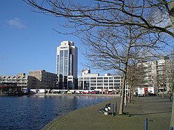
Buildings in Zoetermeer
|
|||
|
|||
 Location in South Holland |
|||
| Coordinates: 52°4′N 4°30′E / 52.067°N 4.500°ECoordinates: 52°4′N 4°30′E / 52.067°N 4.500°E | |||
| Country | Netherlands | ||
| Province | South Holland | ||
| Government | |||
| • Body | Municipal council | ||
| • Mayor | Charlie Aptroot (VVD) | ||
| Area | |||
| • Total | 37.05 km2 (14.31 sq mi) | ||
| • Land | 34.55 km2 (13.34 sq mi) | ||
| • Water | 2.50 km2 (0.97 sq mi) | ||
| Elevation | −3 m (−10 ft) | ||
| Population (May 2014) | |||
| • Total | 123,784 | ||
| • Density | 3,583/km2 (9,280/sq mi) | ||
| Demonym(s) | Zoetermeerder | ||
| Time zone | CET (UTC+1) | ||
| • Summer (DST) | CEST (UTC+2) | ||
| Postcode | 2700–2729 | ||
| Area code | 079 | ||
| Website | www |
||
Zoetermeer (Dutch pronunciation: [ˌzutərˈmeːr]) is a city in the western Netherlands, in the province of South Holland. The municipality covers an area of 37.05 km2 (14.31 sq mi) of which 2.50 km2 (0.97 sq mi) is water. A small village until the late 1960s, it had 6,392 inhabitants in 1950. By 2013 this had grown to 123,328, making it the third largest population centre in the province of South Holland, after Rotterdam and The Hague. It is part of the Haaglanden conurbation.
The name Zoetermeer (Dutch for "freshwater lake") refers to the former lake north of the town (reclaimed in 1614). Because the name literally translates as "sweet lake" local residents have dubbed Zoetermeer "Sweet Lake City".
In the tenth century Zoetermeer was a small village, primarily home to farmers and fishermen. In the 13th century a village centre was formed, which still exists as the historic Dorpsstraat. Until the 17th century there was a lake, called the Zoetermeer. A reminder of this is the "Zoetermeerse Plas" in the Noord Aa recreation area at the northern edge of town; this artificial lake was created when tons of sand were needed to lay the foundation for new housing development, and the area north of Zoetermeer was a good source of this resource.
Until 1935 the village centre was split into two villages, Zoetermeer and Zegwaard. The standard of living at the time was said to be higher in Zoetermeer than in Zegwaard. Seghwaert, an older way of spelling of Zegwaard, is now the name of a neighbourhood outside the old village centre.
Zoetermeer began to grow slightly when the first train service came around 1868. A few decades later the Numico factory started near the station. The real growth started in 1966, when there was an urgent need of houses from people around The Hague. From then they started to build new quarters around the old village centre, so Zoetermeer began to grow and became a city in the meantime.
Although Zoetermeer nowadays has the image of a modern city, there are still remains of the past. Like the old village centre with its small houses and the church with late medieval 15th-century clock tower (on picture, wooden top from 1642), and the old farms, surrounded by modern houses nowadays.
...
Wikipedia


