Zaporizhia
| Запоріжжя (Zaporizhzhya) Запорожье (Zaporozhye) |
|||
|---|---|---|---|
| City of regional significance | |||
  
Metalurhiv Avenue, Khortytsya island and Zaporizhstal
|
|||
|
|||
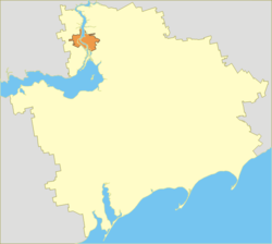
 Zaporizhia Oblast (yellow) with the City of Zaporizhia (orange). |
|||
| Location of Zaporizhia in Ukraine | |||
| Coordinates: 47°50′0″N 35°10′0″E / 47.83333°N 35.16667°ECoordinates: 47°50′0″N 35°10′0″E / 47.83333°N 35.16667°E | |||
| Country |
|
||
| Oblast |
|
||
| Municipality | Zaporizhia Municipality | ||
| Founded | 952 | ||
| City rights | 1806 | ||
| Raions | |||
| Government | |||
| • Mayor | Volodymyr Buriak (Independent) | ||
| Area | |||
| • Total | 334 km2 (129 sq mi) | ||
| Population (2015) | |||
| • Total | 757,650 [2] | ||
| • Density | 2,365.2/km2 (6,126/sq mi) | ||
| • 2001 | 817,900 | ||
| Time zone | EET (UTC+2) | ||
| • Summer (DST) | EEST (UTC+3) | ||
| Postal code | 69xxx | ||
| Area code(s) | +380 61(2) | ||
| Climate | Dfa | ||
| Website | http://www.meria.zp.ua/ | ||
Zaporizhzhia (Ukrainian: Запорі́жжя, translit. Zaporižžja, pronounced [zɑpoˈriʒːɑ]), or Zaporozhye (Russian: Запоро́жье [zəpɐˈroʐjɪ], transcript. Zaporozh'ye, formerly Alexandrovsk (Russian: Алекса́ндровск [ɐlʲɪˈksandrəfsk])) is a city in southeastern Ukraine, situated on the banks of the Dnieper River. It is the administrative center of the Zaporizhia Oblast (province). Administratively, it is incorporated as a city of oblast significance and serves as an administrative center of Zaporizhia Raion, though it does not belong to the raion. Currently the city is the sixth largest in Ukraine. Population: 757,650 (2015 est.).
Until 1921 the city carried the name of Aleksandrovsk after the name of a fortress that was part of the Dnieper Defense Line.
After the establishment of the Soviet regime in Ukraine, in 1921 the name was changed to Zaporizhia (Zaporozhye), literally meaning Trans-Rapids or beyond the rapids, alluding to the rapids which used to exist on the Dnieper River (Dnieper Rapids) at the time, before the construction of the Dnieper Hydroelectric Station in 1932.
...
Wikipedia


