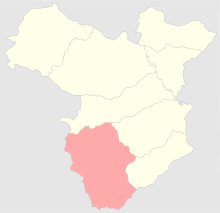
Zangezursky Uyezd
| Zangezursky Uyezd (English) | ||
|---|---|---|
|
||
 |
||
|
||
| Established | 1868 | |
| Abolished | 1921 | |
| Political status | Uyezd | |
| Region | Caucasus | |
| Area | 6,829.7 verst² | |
| Population (1897 census) | ||
| • Total | 137871 | |
| • Density | 20.2 inhab. / verst² | |
| Government | ||
Zangezursky Uyezd (Russian: Зангезурский уезд) was one of the uyezds (administrative units) of Elisabethpol Governorate of the Russian Empire with its center in Goris from 1868 until its formal abolition in 1921 by Soviet authorities.
After the establishment of the Soviet rule over the Southern Caucasus, the uyezd's territory was divided between Soviet Armenia and Soviet Azerbaijan: Armenia acquired the predominantly Armenian-populated Sisian, Goris, Kapan, and Meghri districts and Azerbaijan took Lachin, Kubately, and Zangelan, where the population was mostly Muslim.
Elisabethpol Governorate consisted of Yelizavetpolsky, Nukhisky, Shushinsky, Zangezursky, Kazakhsky, Areshsky, Dzhebrailsky, and Dzhevanshirsky Uyezds. Zangezursky Uyezd was located in the southwest of Elisabethpol Governorate bordering its Dzhevanshirsky Uyezd on the north, Dzhebrailsky and Shushinsky Uyezds on the east, Persian Empire on the south, and Erivan Governorate on the west. The area covered 6,829.7 square verst.
Almost all of the area is mountainous with many gorges and valleys of Lesser Caucasus mountain range. The altitude ranges from 10,000 feet to 12,855 feet at Mount Kapudzhukh, a range dividing Elisabethpol from Erivan Governorate. The rivers in Zangezursky Uyezd are located within the Aras River basin. Bergushad (Bazarchay), Chaundur-chay, Basut-chay, Megri-chay played an important role in irrigation system of the uyezd. Gorysy (Goris) served as the uyezd center.
...
Wikipedia

