Areshsky Uyezd
| Areshsky Uyezd (English) | ||
|---|---|---|
|
||
 |
||
|
||
| Established | 1874 | |
| Abolished | 1929 | |
| Political status | Uyezd | |
| Region | Caucasus | |
| Area | 2,822.9 verst² | |
| Population (1897 census) | ||
| • Total | 67277 | |
| • Density | 23.8 inhab. / verst² | |
| Government | ||
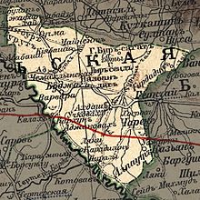
Areshsky Uyezd (Russian: Арешский уезд) was one of the uyezds (administrative units) of Elisabethpol Governorate of the Russian Empire and then of Azerbaijan Democratic Republic with its center in Agdash from 1874 until its formal abolition in 1929 by Soviet authorities.
Elisabethpol Governorate consisted of Elisabethpol, Nukha, Shusha, Zangezur, Kazakh, Areshsky, Jabrayil and Javanshir Uyezds. Aresh uyezd was located in the northeastern part of Elisabethpol Governorate, on the banks of Kura River, bordering Baku Governorate on the east, Nukhinsky Uyezd on the north, Elisabethpol Uyezd on the west and Shusha Uyezd on the southwest. The area of the uyezd was 2822.9 square verst. The territory of the uyezd was mainly made up of lowlands. The uyezd center was first in Uchkovakh, then in Agdash which was considered the largest cotton-trading center in the lowlands of Transcaucasus.
The territory of Areshky Uyezd was located in the Turyanchay River basin. The area was called Aresh (Azerbaijani: Ərəş) in the Middle Ages and was a part of Shirvan Baylarbaylik which significantly weakened after repeated Ottoman - Safavid wars, and was eventually subdued by Shaki Khanate in 1750's. After establishment of Russian rule, Aresh was a part of Nukhinskiy Uyezd of Baku Governorate. In 1874, the territory was transferred into a separate Areshsky Uyezd of newly established Elisabethpol Governorate (1868). It was abolished by Soviet authorities in 1929 and a new Agdash Rayon was established in its place in 1930.
...
Wikipedia

