Yenisei Gulf
| Yenisei Gulf Енисейский залив |
|
|---|---|

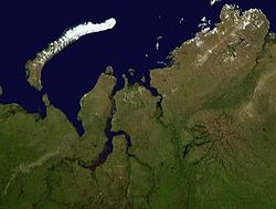
Satellite image of the Yenisei Gulf area
|
|
 |
|
| Location | Kara Sea |
| Coordinates | 72°30′N 81°15′E / 72.500°N 81.250°ECoordinates: 72°30′N 81°15′E / 72.500°N 81.250°E |
| River sources | Yenisei River |
| Basin countries | Russia |
The Yenisei Gulf (Russian: Енисейский залив, Yeniseiskiy Zaliv) is a large and long estuary through which the lower Yenisei River flows into the Kara Sea.
The Yenisei Gulf and its islands belong to the Krasnoyarsk Krai administrative division of the Russian Federation and is part of the Great Arctic State Nature Reserve, the largest nature reserve of Russia.
The Yenisei Gulf is formed by the river widening to an average of 50 km (31 mi) for up to 250 km (160 mi) in a roughly north-south direction, between a latitude of 70° 30′ N in the area around Munguy settlement, north of Dudinka. The whole region of the lower Yenisei is bleak and sparsely inhabited, and the settlements are built on permafrost ground. There is no vegetation except for mosses, lichens and some grass. Coastal waters are habitats for beluga whales.
The maximum depth of Yenisei Gulf is 63 m (208 ft).
The mouth of the Yenisei Gulf is roughly located at 72° 30′ N, in the area of Sibiryakov Island, in the Kara Sea.
The weather pattern in this desolate area is severe, with long and bitter winters and frequent blizzards and gales. The Yenisei estuary is frozen for about nine months in a year and even in summer it is never quite free of ice floes. During the winter the shipping lanes are kept open by icebreaker.
Colin Thubron, In Siberia.
...
Wikipedia
