Yarnell, Arizona
| Yarnell, Arizona | |
|---|---|
| CDP | |

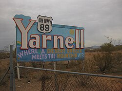
Sign at entrance to Yarnell
|
|
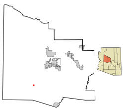
 Location in Yavapai County and the state of Arizona |
|
| Location in the United States | |
| Coordinates: 34°13′21″N 112°44′59″W / 34.22250°N 112.74972°WCoordinates: 34°13′21″N 112°44′59″W / 34.22250°N 112.74972°W | |
| Country | United States |
| State | Arizona |
| County | Yavapai |
| Area | |
| • Total | 8.8 sq mi (22.8 km2) |
| • Land | 8.8 sq mi (22.9 km2) |
| • Water | 0.0 sq mi (0.0 km2) |
| Elevation | 4,780 ft (1,457 m) |
| Population (2010) | |
| • Total | 649 |
| • Density | 73.1/sq mi (28.2/km2) |
| Time zone | MST (UTC-7) |
| ZIP code | 85362 |
| Area code(s) | 928 |
| FIPS code | 04-84980 |
| GNIS feature ID | 0014039 |
Yarnell is a census-designated place (CDP) in Yavapai County, Arizona, United States. The population of Yarnell was 649 at the 2010 census. Yarnell's economy is based on ranching, mining and services to travelers and retirees. Peeples Valley, three miles north, is closely linked to Yarnell.
Gold was discovered in Yarnell about 1865 by Charles Genung (1839–1916), a well-known area pioneer. The community is named for Harrison Yarnell, a later prospector, who discovered the Yarnell mine in 1873. Old U.S. Route 89 (now State Route 89), which goes through Yarnell, was paved in 1933, and for many years was the main highway from Phoenix to Wickenburg, Prescott and northern Arizona.
On June 30, 2013, the Yarnell Hill Fire destroyed half of the town and killed 19 firefighters.
Yarnell is located at 34°13′21″N 112°44′59″W / 34.22250°N 112.74972°W (34.222569, -112.749608).
According to the United States Census Bureau, the CDP has a total area of 8.8 square miles (23 km2), all of it land.
Yarnell Hill, which Highway 89 descends 1,300 feet in four miles, is a popular scenic drive. There is a developed lookout point at the top - only accessible from the downhill road.
The Shrine of St. Joseph of the Mountains is a Christian religious monument which features statuary hidden in the boulders. A short trail leads visitors through the stations of the cross.
...
Wikipedia

