Wyangala
|
Wyangala New South Wales |
|||||||
|---|---|---|---|---|---|---|---|

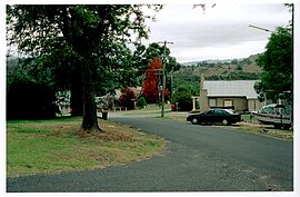
Wyangala village, looking towards St Vincent's Church, corner of Waugoola and Wirong Rds.
|
|||||||
| Coordinates | 33°57′S 148°59′E / 33.950°S 148.983°ECoordinates: 33°57′S 148°59′E / 33.950°S 148.983°E | ||||||
| Population | 227 (2011 census) | ||||||
| Postcode(s) | 2808 | ||||||
| Elevation | 341 m (1,119 ft) | ||||||
| Location | |||||||
| LGA(s) | Cowra Shire | ||||||
| County | King County | ||||||
| State electorate(s) | Cootamundra | ||||||
| Federal Division(s) | Hume | ||||||
|
|||||||
Wyangala /ˈwaɪæŋɡɑːlə/ is a small village in the Lachlan Valley, near the junction of the Abercrombie and Lachlan Rivers, just below the Wyangala Dam wall. It is in the South West Slopes of New South Wales, Australia, and about 320 km (200 mi) west of the state capital, Sydney.
The village was named after a Wiradjuri word of unknown meaning. The Wiradjuri people were the original inhabitants of the Lachlan Valley, with campsites along river flats, on open land and by rivers. In 1817 John Oxley and George William Evans were the first Europeans to explore the valley. White settlement commenced several years later in the 1830s, leading to violent clashes between the native population and the settlers.
The present-day village was established in 1928, during the construction of Wyangala Dam. However, in the same area, there was a scattered pioneering settlement known as Wyangala Flats, which was established in the 1840s. This settlement was submerged under water following the completion of Wyangala Dam in 1935. Although Wyangala grew substantially during periods of dam construction, the population dwindled in the subsequent years. This resulted in the removal of houses and the closure of most businesses, leaving Wyangala with a small primary school, a Catholic church, sports fields and parks, in addition to other facilities. There are no buildings of historical note, as the original purpose of the village was to solely provide utilitarian accommodation for the construction workers.
...
Wikipedia

