Wunghnu, Victoria
|
Wunghnu Victoria |
|||||||||||||
|---|---|---|---|---|---|---|---|---|---|---|---|---|---|

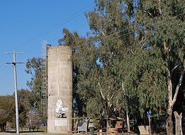
Rest area at Wunghnu showing the mural on the water tower
|
|||||||||||||
| Coordinates | 36°09′S 145°25′E / 36.150°S 145.417°ECoordinates: 36°09′S 145°25′E / 36.150°S 145.417°E | ||||||||||||
| Population | 535 (2011 census) | ||||||||||||
| Postcode(s) | 3635 | ||||||||||||
| Location |
|
||||||||||||
| LGA(s) | Shire of Moira | ||||||||||||
| State electorate(s) | Shepparton | ||||||||||||
| Federal Division(s) | Murray | ||||||||||||
|
|||||||||||||
|
|||||||||||||
Wunghnu (/ˈwʌn.juː/ WUN-ew) is a small town in the Goulburn Valley region of northern Victoria, Australia. The town is located in the Shire of Moira local government area, 204 kilometres (127 mi) north of the state capital, Melbourne and has a population of 535. The local railway station was opened on the Goulburn Valley railway in 1881, but does not see any passenger services, being the site of a siding and grain silos.
Wunghnu Post Office opened earlier on 6 July 1877.
Wunghnu is situated on the Goulburn Valley Highway (Carlisle Street) and the Nine Mile Creek runs through the town at the north end. Wunghnu Primary School is located on the west side of the highway near the creek. The 1u cafe (recently re-opened in May 2012) is also located at the north end of town on the east side of the highway opposite the water tower and Graham Park and local public toilets are located near the creek. This area is a popular rest stop for travellers.
The town is noted for its canoe trees; Grey Box eucalypts that were stripped of bark by the indigenous inhabitants to construct watercraft. The scars on these stripped trees can be seen in the town common bushland reserve, bordering the Goulburn Valley Highway, the main throughway through town. Wunghnu is pronounced "one-ewe" and is therefore the subject of jokes professing it to be the smallest sheep station in the world.
...
Wikipedia

