Numurkah, Victoria
|
Numurkah Victoria |
|||||||||||||
|---|---|---|---|---|---|---|---|---|---|---|---|---|---|

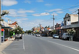
Melville St, the main street of Numurkah
|
|||||||||||||
| Coordinates | 36°05′0″S 145°26′0″E / 36.08333°S 145.43333°ECoordinates: 36°05′0″S 145°26′0″E / 36.08333°S 145.43333°E | ||||||||||||
| Population | 4,768 (2011 census) | ||||||||||||
| Established | 1868 | ||||||||||||
| Postcode(s) | 3636 | ||||||||||||
| Elevation | 108 m (354 ft) | ||||||||||||
| Location |
|
||||||||||||
| LGA(s) | Shire of Moira | ||||||||||||
| State electorate(s) | Shepparton | ||||||||||||
| Federal Division(s) | Murray | ||||||||||||
|
|||||||||||||
|
|||||||||||||
Numurkah (/njuːˈmɜːrkə/ or locally [njʉːˈmɜːkə] new-MUR-kə) is a town in Victoria, Australia, located on the Goulburn Valley Highway, 37 kilometres (23 mi) north of Shepparton, in the Shire of Moira. At the 2011 census, Numurkah had a population of 4,768.
The area was occupied by the Yorta Yorta people prior to European settlement. Squatters moved into the area from NSW in the late 1830s. After the pastoral runs were made available for farm selection, the township of Numurkah was surveyed in 1875, the Post Office opening 2 November 1878. The local railway station was opened on the Goulburn Valley railway in 1881, but has not seen any passenger services since 1993 when the train to Cobram was withdrawn. The station building remains in private ownership, and a footbridge crosses the line.
The name is thought to be derived from an Aboriginal word meaning war shield, although a recent authority thinks that this is mistaken. The town hosts an art show in March, a fishing competition in April, and go-kart championships in September and a car show in December.
...
Wikipedia

