Wormshill
| Wormshill | |
|---|---|
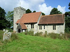
 St Giles Church, Wormshill |
|
| Wormshill shown within Kent | |
| Population | 201 (2011 Census) |
| OS grid reference | TQ879574 |
| • London | 38 miles (61 km) |
| District | |
| Shire county | |
| Region | |
| Country | England |
| Sovereign state | United Kingdom |
| Post town | SITTINGBOURNE |
| Postcode district | ME9 |
| Dialling code | 01622 |
| Police | Kent |
| Fire | Kent |
| Ambulance | South East Coast |
| EU Parliament | South East England |
| UK Parliament | |
Wormshill (/wɜːrmzˈhɪl/ wurmz-HILL), historically Wormsell, is a small village and civil parish within the Borough of Maidstone, Kent, England. The parish is approximately 7 miles (11 km) south of the Swale and 8 miles (13 km) east of Maidstone. The village of Frinsted lies 0.6 miles (1 km) to the east and Bicknor 1 1⁄2 miles (2.4 km) to the north-west; while Hollingbourne is 3 miles (5 km) to the south-west. The village lies on an exposed high point of the North Downs, within the Kent Downs Area of Outstanding Natural Beauty.
Archaeological and toponymic evidence of Wormshill's existence predates its appearance in the Domesday survey of 1086. The village contains a number of heritage-listed buildings, which include a Norman church, a public house and one of the oldest surviving post office buildings in the United Kingdom. The fields and woodland surrounding Wormshill have changed little in the past 500 years, and the village itself remains rural with a low population density compared to the national average. The population of 200 is a mixture of agricultural workers employed by local farms and professional residents who commute to nearby towns.
...
Wikipedia

