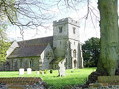
Frinsted
| Frinsted | |
|---|---|
 St Dunstan's church |
|
| Frinsted shown within Kent | |
| Population | 143 (2011 Census) |
| OS grid reference | TQ8957 |
| Civil parish | |
| District | |
| Shire county | |
| Region | |
| Country | England |
| Sovereign state | United Kingdom |
| Post town | Sittingbourne |
| Postcode district | ME9 |
| Dialling code | 01622 |
| Police | Kent |
| Fire | Kent |
| Ambulance | South East Coast |
| EU Parliament | South East England |
Frinsted or Frinstead is a small village and civil parish in the ecclesiastical parish of Wormshill and in the Maidstone District of Kent, England. and has been a recorded settlement (under the name Fredenestede) as far back as the Domesday Book and indeed was the only settlement in the surrounding area to be described at the time to have a church. The village exists in the Hundred of Eyhorne (and has been mentioned as such dating back to the Kent Hundred Rolls of 1274 to 1275).
The parish is situated on the North Downs between Sittingbourne and Maidstone some ten miles (16 km) south of The Swale. To the West lies the village of Wormshill, to the North East the village of Milstead and the hamlet of Kingsdown (including the Torry Hill estate) and to the South and South East are the villages of Doddington and Newnham. The part of the parish northward of the church is in the division of East Kent, but the church itself, and the remaining part of it is in West Kent.
The village is surrounded by former manor houses or "courts" being to the east Wrinsted court and to the west, Yokes Court and Madams Court.
The population is relatively unchanged in the past 200 years. In 1801 Frinsted's total population was 153. After rising to 219 around 1871, by the 1901 census the population had dropped to 126. By 1971 the population was 138. At the 2001 census, the population was 171, falling at the 2011 Census to 143.
...
Wikipedia

