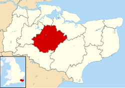
Borough of Maidstone
| Borough of Maidstone | |
|---|---|
| Non-metropolitan district | |
 Maidstone shown within Kent |
|
| Sovereign state | United Kingdom |
| Constituent country | England |
| Region | South East England |
| Non-metropolitan county | Kent |
| Status | Non-metropolitan district |
| Admin HQ | Maidstone |
| Incorporated | 1 April 1974 |
| Government | |
| • Type | Non-metropolitan district council |
| • Body | Maidstone Borough Council |
| • Leadership | Committees (Conservative / Liberal Democrat) |
| • MPs |
Helen Whately Helen Grant |
| Area | |
| • Total | 151.9 sq mi (393.3 km2) |
| Area rank | 103rd (of 326) |
| Population (mid-2015 est.) | |
| • Total | 164,500 |
| • Rank | 114th (of 326) |
| • Density | 1,100/sq mi (420/km2) |
| • Ethnicity | 97.3% White 1.1% S.Asian |
| Time zone | GMT (UTC0) |
| • Summer (DST) | BST (UTC+1) |
| ONS code | 29UH (ONS) E07000110 (GSS) |
| OS grid reference | TQ7588156056 |
| Website | www |
The Borough of Maidstone is a local government district with borough status in Kent, England. Its administrative centre is Maidstone, the county town of Kent.
The borough was formed on 1 April 1974 by the merger of the Municipal Borough of Maidstone with the rural districts of Maidstone and Hollingbourne, under the Local Government Act 1972.
The borough covers an area generally to the east and south of the town of Maidstone: as far north as the M2 motorway; east down the M20 to Lenham; south to a line including Staplehurst and Headcorn; and west towards Tonbridge. Generally speaking, it lies between the North Downs and the Weald, and covers the central part of the county. The M20 motorway crosses it from west to east, as does High Speed 1.
Geologically, the Greensand ridge lies to the south of the town. The very fine sand provides a good source for glass-making. The clay vale beyond, through which flow the three rivers which meet at Yalding; the Medway, the Beult and the Teise; and the chalk North Downs all provide raw materials for paper- and cement-making; which are also local industries.
...
Wikipedia
