Woodward Township, Lycoming County, Pennsylvania
| Woodward Township, Lycoming County, Pennsylvania |
|
|---|---|
| Township | |

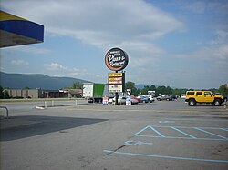
The Harvest Moon is a Woodward Township landmark on U.S. Route 220
|
|
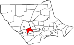
 Map of Lycoming County, Pennsylvania highlighting Woodward Township |
|
 Map of Lycoming County, Pennsylvania |
|
| Coordinates: 41°13′47″N 77°8′38″W / 41.22972°N 77.14389°WCoordinates: 41°13′47″N 77°8′38″W / 41.22972°N 77.14389°W | |
| Country | United States |
| State | Pennsylvania |
| County | Lycoming |
| Settled | 1772 |
| Incorporated | 1855 |
| Area | |
| • Total | 13.6 sq mi (35.3 km2) |
| • Land | 13.2 sq mi (34.1 km2) |
| • Water | 0.5 sq mi (1.2 km2) |
| Elevation | 768 ft (234 m) |
| Population (2010) | |
| • Total | 10,707 |
| • Estimate (2016) | 2,167 |
| • Density | 182.2/sq mi (70.3/km2) |
| Time zone | Eastern (EST) (UTC-5) |
| • Summer (DST) | EDT (UTC-4) |
| FIPS code | 42-081-86456 |
| GNIS feature ID | 1216778 |
Woodward Township is a township in Lycoming County, Pennsylvania, United States. The population was 2,397 at the 2000 census. It is part of the Williamsport, Pennsylvania Metropolitan Statistical Area.
Woodward Township was formed on November 23, 1855 by dividing Anthony Township. It is named for Apollos Woodward who was an associate judge in Williamsport at the time. The population of Woodward Township has grown to 2,397 as of the 2000 census. This is up from 817 during the 1890 census. The township which is bisceted by Quenshukeny Run semi-rural in nature. The northern parts of the township less heavily populated than the southern parts which lie on U.S. Route 220 and serve as a suburb for Williamsport and Jersey Shore.
When Woodward township was first settled by migrants from Europe it was outside the boundaries of the Province of Pennsylvania. These settlers were not under the rule or protection of the colonial government in Philadelphia. Together they formed their own form of government that was administerd by a group of pioneers known as the Fair Play Men. These early settlers banded together to provide law and order to a land that was wild and dangerous.
Brattan Caldwell, a native of County Kildare, Ireland, migrated to the Thirteen Colonies in 1770. He arrived in Philadelphia and from there moved to Lancaster County. He joined with other pioneers and they followed the Susquehanna River and West Branch Susquehann River into the frontier. Brattan Caldwell and the other settlers arrived in what is now Woodward Township in 1772. They cleared land along the river its tributaries. Caldwell married Elcy Hughes in the winter of 1775 on the south side of the river in Nippenose Township. This part of the West Branch Susquehanna River Valley was under the jurisdiction and protection of the colonial government of Pennsylvania. The Hughes' were married by a Northumberland County Justice of the Peace. It was the first marriage to take place in the settlements west of Lycoming Creek.
...
Wikipedia
