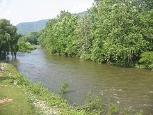
Lycoming Creek
| Lycoming Creek | |
|---|---|

Lycoming Creek at Trout Run in Lycoming County, Pennsylvania
|
|
| Country | Pennsylvania, United States |
| Basin features | |
| Main source | near McNett Township, Lycoming County 2,161 feet (659 m) |
| River mouth | West Branch Susquehanna River, at Williamsport |
| Basin size | 272 square miles (700 km2) |
| Physical characteristics | |
| Length | 37.5 miles (60.4 km) |
Coordinates: 41°13′44″N 77°2′26″W / 41.22889°N 77.04056°W
Lycoming Creek is a 37.5-mile-long (60.4 km)tributary of the West Branch Susquehanna River located in Tioga and Lycoming counties in Pennsylvania in the United States.
As the crow flies, Lycoming County is about 130 miles (209 km) northwest of Philadelphia and 165 miles (266 km) east-northeast of Pittsburgh. Lycoming Creek has its river source in Tioga County and is 25 miles (40 km) in length from the Tioga County / Lycoming County line to its confluence with the West Branch Susquehanna River at Williamsport. Smaller streams feeding Lycoming Creek include Pleasant Stream, Grays Run, Roaring Branch, Hoagland Run, and Trout Run.
Approximately 81.5% of the Lycoming Creek watershed is in Lycoming County, with 16.5% in Tioga County, and 1.5% in Sullivan County. The watershed has a total population of 19,978 (as of 2000) and a total area of 272 square miles (700 km2). Of that area, 222 square miles (570 km2) are forested, 45 square miles (120 km2) are given to agricultural uses, only 3 square miles (7.8 km2) are developed, and the remaining 1 square mile (2.6 km2) is classified as barren.
...
Wikipedia
