Wolfscastle
Wolf's Castle
|
|
|---|---|
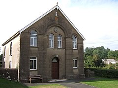
 Congregational chapel, Wolf's Castle |
|
| Wolf's Castle shown within Pembrokeshire | |
| Population | 642 (2011 census) |
| OS grid reference | SM957267 |
| Community |
|
| Principal area | |
| Ceremonial county | |
| Country | Wales |
| Sovereign state | United Kingdom |
| Post town | HAVERFORDWEST |
| Postcode district | SA62 |
| Dialling code | 01437 |
| Police | Dyfed-Powys |
| Fire | Mid and West Wales |
| Ambulance | Welsh |
| EU Parliament | Wales |
| UK Parliament | |
Wolfscastle (Welsh: Casblaidd) also spelt Wolf's Castle, is a village and community in Pembrokeshire, between Haverfordwest and Fishguard, in southwest Wales. It was historically in the parish of St Dogwells.
Wolfscastle comprises two small villages; Wolfscastle proper, at the top of a hill, and Ford, situated in the river valley below. The remains of a motte and bailey castle lie in the upper village, a strategic location determined by its situation at the northern end of Treffgarne gorge. The village lies at the confluence of the Western Cleddau and the Anghof rivers, in the parish of St Dogwell's.
The A40 road, the London to Fishguard trunk route, passes through Wolfscastle and provides the main transport route to and from the village, with a regular bus service connecting with the major towns of the area.
A railway line from Clarbeston Road to Fishguard Harbour carries two Swansea–Fishguard boat trains in each direction daily through Ford. At one time, there was a station named Wolf's Castle Halt near Ford for both passengers and the loading of milk from local farms, but this is no longer in existence, having closed in 1964 after the Beeching cuts.
Musland Farm was once the residence of Captain William Davies Evans, the first utiliser of the Evans Gambit in chess.
The castle formed part of the series of defences constructed by the Normans after 1093 known as the Landsker Line, providing a general boundary between the English-speaking south and the Welsh-speaking north.
...
Wikipedia

