Wisborough Green
| Wisborough Green | |
|---|---|
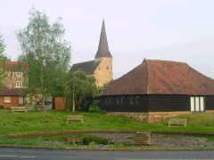
 Parish church of St. Peter ad Vincula and pond |
|
| Wisborough Green shown within West Sussex | |
| Area | 17.57 km2 (6.78 sq mi) |
| Population | 1,414 (2011, including Bedham) |
| • Density | 77/km2 (200/sq mi) |
| OS grid reference | TQ049259 |
| • London | 37 miles (60 km) NNE |
| Civil parish |
|
| District | |
| Shire county | |
| Region | |
| Country | England |
| Sovereign state | United Kingdom |
| Post town | BILLINGSHURST |
| Postcode district | RH14 |
| Dialling code | 01403 |
| Police | Sussex |
| Fire | West Sussex |
| Ambulance | South East Coast |
| EU Parliament | South East England |
| UK Parliament | |
| Website | Wisborough Green |
Wisborough Green is a village and civil parish in the Chichester district of West Sussex, England, 2 miles (3.2 km) west of Billingshurst on the A272 road.
Newbridge, where the A272 crosses the River Arun 1 mile (1.6 km) east of the village, was the highest point of the Arun navigation, and the southern end of the Wey and Arun Canal. Newbridge Wharfe, on the southern side of the bridge, was an important part of the local transport system in the nineteenth century.
An electoral ward in the same name exists. This ward includes Kirdford and at the 2011 Census has a ward population of 2,477.
Around the large village green, used for playing cricket and football, there are two pubs, the Cricketers Arms and the Three Crowns, and a village shop. There is also a cricket pavilion on the green which doubles as a social club. Further out there is another pub, the Bat & Ball, near Fishers Farm, a farm adventure park. Since Victorian times there has been a primary school in the village. The original building was closed in 1996 and was converted into a number of houses. Since then the whole school (reception to year 6) has been on the same site, opposite the old one.
The parish has a land area of 1756.9 hectares (4339.5 acres). The 2001 census recorded a population of 1,360 people (667 male and 693 female) living in 570 households, with an average of 2.93 people per house. Of 964 people aged 16–74, 621 were economically active.
The Church of England parish church of St. Peter ad Vincula ("St. Peter in Chains") is on higher ground near a small pond with pollarded willow trees. Its unusual dedication is after the ancient Basilica of San Pietro in Vincoli in Rome. The current vicar is the Reverend Clive Jenkins. There is a Methodist chapel, and a family church that meets in the village hall.
...
Wikipedia

