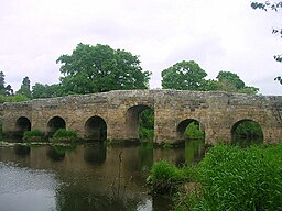
River Arun
| Arun |
| Tarrant |
| River |
|
|
| Country |
England |
| County |
West Sussex |
|
| Tributaries |
| - left |
River Stor, River Kird, North River
|
| - right |
River Rother |
| Towns |
Horsham, Arundel, Littlehampton
|
|
|
| Source |
|
| - location |
St Leonard's Forest, West Sussex
|
| - elevation |
125 m (410 ft) |
| Mouth |
|
| - location |
Littlehampton, West Sussex
|
| - elevation |
0 m (0 ft) |
|
| Length |
60 km (37 mi) |
| Basin |
376 sq mi (974 km2) |
| Discharge |
for Pallingham Quay |
| - average |
4.78 m3/s (169 cu ft/s) |
| - max |
78.5 m3/s (2,772 cu ft/s) |
| - min |
0.31 m3/s (11 cu ft/s) |
| Discharge elsewhere (average) |
| - Alfoldean |
1.84 m3/s (65 cu ft/s) |
|
| Protection status |
|
|
|
| Official name |
Arun Valley |
| Designated |
16 December 1999 |
|

