Chichester District
| Chichester District | |
|---|---|
| Non-metropolitan district | |
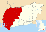
 Chichester shown within West Sussex |
|
| Sovereign state | United Kingdom |
| Constituent country | England |
| Region | South East England |
| Non-metropolitan county | West Sussex |
| Status | Non-metropolitan district |
| Admin HQ | Chichester |
| Incorporated | 1 April 1974 |
| Government | |
| • Type | Non-metropolitan district council |
| • Body | Chichester District Council |
| • Leadership | Leader & Cabinet (Conservative) |
| • MPs |
Nick Herbert Francis Maude Andrew Tyrie |
| Area | |
| • Total | 303.60 sq mi (786.32 km2) |
| Area rank | 46th (of 326) |
| Population (mid-2015 est.) | |
| • Total | 117,000 |
| • Rank | 192nd (of 326) |
| • Density | 390/sq mi (150/km2) |
| • Ethnicity | 98.4% White |
| Time zone | GMT (UTC0) |
| • Summer (DST) | BST (UTC+1) |
| Website | www |
Chichester is a largely rural local government district in West Sussex, England. Its council is based in the city of Chichester.
The district was formed on 1 April 1974, under the Local Government Act 1972, as a merger of the municipal borough (city) of Chichester and the Rural Districts of Midhurst, Petworth and part of the former Chichester Rural District.
Chichester District Council has 48 councillors, representing 29 wards. Chichester itself has four of those wards (North, South, East and West) whilst the remaining wards comprise groups of villages; see Wards of Chichester District. Local elections are held every four years and at the May 2011 and 2015 elections, the Conservative party retained control.
There are 67 civil parishes in Chichester District. Apart from the City of Chichester, and the three towns of Midhurst, Selsey and Petworth, most are villages.
Chichester District occupies the western part of West Sussex, bordering on Hampshire to the west and Surrey to the north. The districts of Arun and Horsham abut to the east; the English Channel to the south. The district is divided by the South Downs escarpment, with the northern part being in the Weald, composed of a mixture of sandstone ridges and low-lying clays known as the Western Weald. To the south the dip slope of the downs falls gently to a flat coastal plain and the sea. The Western Weald is drained by the River Arun and its tributuaries including the rivers Lox, Kird and especially the River Rother and its tributuaries the River Lod and the Haslingbourne Stream. On the northern boundary Blackdown is the highest point in Sussex, while further east around Loxwood the land is low and quite flat. The south of the district has many permeable chalk and gravel areas and is drained by two winterbournes, the River Lavant and River Ems, which are usually dry in the summer. The large inlet known as Chichester Harbour and the headland of Selsey Bill are conspicuous features of the coast.
...
Wikipedia
