Wirsitz
| Wyrzysk | |||
|---|---|---|---|

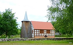
Local church overseeing the river
|
|||
|
|||
| Coordinates: 53°9′9″N 17°16′4″E / 53.15250°N 17.26778°E | |||
| Country |
|
||
| Voivodeship | Greater Poland | ||
| County | Piła | ||
| Gmina | Wyrzysk | ||
| Established | fourteenth century | ||
| Town rights | fifteenth century | ||
| Government | |||
| • Mayor | Bogusława Jagodzińska | ||
| Area | |||
| • Total | 4.12 km2 (1.59 sq mi) | ||
| Elevation | 90 m (300 ft) | ||
| Population (2006) | |||
| • Total | 5,234 | ||
| • Density | 1,300/km2 (3,300/sq mi) | ||
| Time zone | CET (UTC+1) | ||
| • Summer (DST) | CEST (UTC+2) | ||
| Postal code | 89-300 | ||
| Area code(s) | +48 67 | ||
| Car plates | PP | ||
| Website | http://www.wyrzysk.pl | ||
Wyrzysk [ˈvɨʐɨsk] (![]() listen) (German: Wirsitz) is a town in Poland with 5,263 (2004) inhabitants, situated in Piła County, Greater Poland Voivodeship.
listen) (German: Wirsitz) is a town in Poland with 5,263 (2004) inhabitants, situated in Piła County, Greater Poland Voivodeship.
Gmina (commune) Wyrzysk has a population of about 14,500 and occupies an area of 160.7 km². It lies on the northern edge of Greater Poland Voivodeship; in the east it borders gmina Sadki in the Kuyavian-Pomeranian Voivodeship. Of the district area, 117.11 km² are occupied by arable land and 19.65 km² by forests.
The commune used to be cut through by national road No. 10 leading from Szczecin to Warsaw but a bypass has now been built. This bypass connects Wyrzysk with Piła (37 km) and Bydgoszcz (55 km). The railway station in Osiek nad Notecią also provides a railway connection with Piła (39 km) and Bydgoszcz (48 km).
The commune lies in Krajna Plateau. Its southern border is formed by the River Noteć with its tributary, the Łobżonka, which cuts through the picturesque moraine hills rising over the wide valley of the Noteć. One of these hills, Dębowa Góra, reaches a height of 192 metres above sea level and is the highest elevation of the Krajna Region. Over 60 per cent of the commune is protected as an area of scenic beauty.
...
Wikipedia


