Noteć
| Noteć | |
| River | |
|
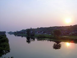
Noteć near Santok
|
|
| Country | Poland |
|---|---|
| Voivodeships | Kuyavian-Pomeranian, Greater Poland, Lubusz |
| Tributaries | |
| - left | Mała Noteć, Gąsawka, Kcyninka, Gulczanka |
| - right | Gwda, Drawa |
| Towns/Cities | Inowrocław, Kruszwica, Pakość, Barcin, Łabiszyn, Nakło nad Notecią, Ujście, Czarnków, Wieleń, Drezdenko |
| Source | Between Szczecin and Bogołomia (Gmina Chodecz) 52°22′29″N 19°00′25″E / 52.37472°N 19.00694°E |
| Mouth |
Warta at Santok 52°44′09″N 15°24′20″E / 52.73583°N 15.40556°ECoordinates: 52°44′09″N 15°24′20″E / 52.73583°N 15.40556°E |
| Length | 388 km (241 mi) |
| Basin | 17,300 km2 (6,680 sq mi) |
| Discharge | |
| - average | 73 m3/s (2,578 cu ft/s) |
Noteć (German: Netze, Latin: Natissis) is a river in central Poland with a length of 388 km (241 mi) (7th longest) and a basin area of 17,300 km2 (6,700 sq mi). It is the largest tributary of the Warta river and lies completely within Poland.
It rises in the Kuyavian-Pomeranian Voivodeship and flows through Lake Gopło and the town of Inowrocław. It reaches the voivodeship of Greater Poland in the historic Pałuki region south of Piła. Further down in Lubusz Voivodeship, it empties into the Warta at Santok near Gorzów Wielkopolski. The river is usually subdivided into an upper part (Noteć Górna), running from its source to Nakło, and a lower part (Noteć Dolna) from Nakło to its mouth into the Warta River. At Nakło, the Bydgoszcz Canal, built in 1773/74, connects the Noteć River with the Brda river, a tributary of the Vistula, at Bydgoszcz.
The lower sections down from the mouth of the Drawa (near Krzyż Wielkopolski) are located within the broad Toruń-Eberswalde Urstromtal. These large wetlands, with only two historic river crossings at Santok and Drezdenko, are sparsely populated.
...
Wikipedia

