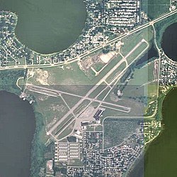
Winter Haven Airport
|
Winter Haven's Gilbert Airport Winter Haven Municipal Airport |
|||||||||||||||
|---|---|---|---|---|---|---|---|---|---|---|---|---|---|---|---|

2006 USGS airphoto
|
|||||||||||||||
| Summary | |||||||||||||||
| Airport type | Public | ||||||||||||||
| Owner | City of Winter Haven | ||||||||||||||
| Serves | Winter Haven, Florida | ||||||||||||||
| Elevation AMSL | 145 ft / 44 m | ||||||||||||||
| Coordinates | 28°03′46″N 081°45′12″W / 28.06278°N 81.75333°W | ||||||||||||||
| Map | |||||||||||||||
| Location of Winter Haven's Gilbert Airport | |||||||||||||||
| Runways | |||||||||||||||
|
|||||||||||||||
| Statistics (2009) | |||||||||||||||
|
|||||||||||||||
|
Source: Federal Aviation Administration
|
|||||||||||||||
| Aircraft operations | 60,000 |
|---|---|
| Based aircraft | 158 |
Winter Haven's Gilbert Airport (IATA: GIF, ICAO: KGIF, FAA LID: GIF) is a city-owned, public-use airport located three nautical miles (6 km) northwest of the central business district of Winter Haven, a city in Polk County, Florida, United States. It is owned by the City of Winter Haven. It is also known as Winter Haven Municipal Airport or Gilbert Field. Jack Browns Seaplane Base is located adjacent to the airport, connected by a taxiway.
During World War II, Gilbert Field was an auxiliary airfield for the Lakeland (later Lodwick) School of Aeronautics at the Lakeland Lodwick Field airport. The school provided basic pilot training to United States Army Air Forces and British Royal Air Force flying cadets from the airfield under contract. Flight training was performed until the end of the war.
Winter Haven's Gilbert Airport covers an area of 520 acres (210 ha) at an elevation of 145 feet (44 m) above mean sea level. It has two asphalt paved runways: 5/23 is 5,005 by 100 feet (1,526 x 30 m) and 11/29 is 4,001 by 100 feet (1,220 x 30 m).
For the 12-month period ending November 17, 2009, the airport had 60,000 general aviation aircraft operations, an average of 164 per day. At that time there were 158 aircraft based at this airport: 87% single-engine, 9% multi-engine, 1% jet and 2% glider.
...
Wikipedia

