Winfield Township, New Jersey
| Winfield Township, New Jersey | |
|---|---|
| Township | |
| Township of Winfield | |
 Map of Winfield Township in Union County. Inset: Location of Union County highlighted in the State of New Jersey. |
|
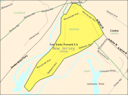
 Census Bureau map of Winfield Township, New Jersey. |
|
| Coordinates: 40°38′00″N 74°17′29″W / 40.633274°N 74.291296°WCoordinates: 40°38′00″N 74°17′29″W / 40.633274°N 74.291296°W | |
| Country |
|
| State |
|
| County | Union |
| Incorporated | July 28, 1941 |
| Government | |
| • Type | Township |
| • Body | Township Committee |
| • Mayor | Margaret M. McManus (D, term ends December 31, 2016) |
| • Clerk | June Planas (acting) |
| Area | |
| • Total | 0.177 sq mi (0.458 km2) |
| • Land | 0.177 sq mi (0.458 km2) |
| • Water | 0.000 sq mi (0.000 km2) 0.09% |
| Area rank | 561st of 566 in state 21st of 21 in county |
| Elevation | 43 ft (13 m) |
| Population (2010 Census) | |
| • Total | 1,471 |
| • Estimate (2015) | 1,510 |
| • Rank | 514th of 566 in state 21st of 21 in county |
| • Density | 8,320.1/sq mi (3,212.4/km2) |
| • Density rank | 44th of 566 in state 3rd of 21 in county |
| Time zone | Eastern (EST) (UTC-5) |
| • Summer (DST) | Eastern (EDT) (UTC-4) |
| ZIP code | 07036 – Linden |
| Area code(s) | 908 |
| FIPS code | 3403981650 |
| GNIS feature ID | 0882215 |
| Website | www |
Winfield Township (also called Winfield Park) is a township in Union County, New Jersey, in the United States. As of the 2010 United States Census, the township's population decreased to 1,471, the lowest recorded in any decennial census, reflecting a decline of 43 (-2.8%) from the 1,514 counted in the 2000 Census, which had in turn declined by 62 (-3.9%) from the 1,576 counted in the 1990 Census. Winfield and Linden share the same ZIP code.
Winfield Township was incorporated as a township by an act of the New Jersey Legislature on August 6, 1941, from portions of Clark and Linden, passing over the Governor's veto.
The Winfield Park Mutual Ownership Defense Housing Project (Project No. 28071) is a 700 unit development of 254 buildings that was originally planned and developed by and built for the defense workers of the Kearny, New Jersey, shipyards. This was the last of eight projects undertaken by the Mutual Ownership Defense Housing Division of the Federal Works Agency under the leadership of Colonel Lawrence Westbrook. At earlier stages Winfield Park was also known as the Rahway River Park Project. John T. Rowland served as the architect of the project. Winfield Park is located immediately off of exit 136 of the Garden State Parkway; the municipalities of Cranford, Linden and Clark surround Winfield Township, a governmental entity established to enclose the Winfield Park Project. The Township is bordered on three sides by the Rahway River and Rahway River Park (which adds substantially to the park-like setting envisioned by the planners). Units range in size and type from single family homes to two story (plus basement) two- and three-bedroom apartments, better known today as Townhouses; to one story (plus basement) two-bedroom apartments; and one-bedroom apartments, better known to residents as "bachelors." Within the town are located an elementary school, two-store shopping center and Senior Citizen Hall, Community Center, Mutual Housing Office and Garage, Volunteer Fire and Ambulance Squad Building, and Municipal Building/ Police Office.
...
Wikipedia
