Clark, New Jersey
| Clark, New Jersey | |
|---|---|
| Township | |
| Township of Clark | |
| Motto: Growth, Industry, History | |
 Map of Clark Township in Union County. Inset: Location of Union County in New Jersey. |
|
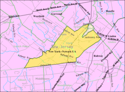
 Census Bureau map of Clark, New Jersey |
|
| Coordinates: 40°37′06″N 74°18′57″W / 40.61845°N 74.315957°WCoordinates: 40°37′06″N 74°18′57″W / 40.61845°N 74.315957°W | |
| Country | |
| State |
|
| County | Union |
| Incorporated | March 23, 1864 |
| Named for | Abraham Clark |
| Government | |
| • Type | Faulkner Act Mayor-Council |
| • Body | Township Council |
| • Mayor | Salvatore F. "Sal" Bonaccorso (R, term ends December 31, 2016) |
| • Administrator | John Laezza |
| • Clerk | Edie Merkel |
| Area | |
| • Total | 4.494 sq mi (11.640 km2) |
| • Land | 4.301 sq mi (11.141 km2) |
| • Water | 0.193 sq mi (0.499 km2) 4.29% |
| Area rank | 284th of 566 in state 11th of 21 in county |
| Elevation | 39 ft (12 m) |
| Population (2010 Census) | |
| • Total | 14,756 |
| • Estimate (2015) | 15,535 |
| • Rank | 170th of 566 in state 13th of 21 in county |
| • Density | 3,430.5/sq mi (1,324.5/km2) |
| • Density rank | 188th of 566 in state 16th of 21 in county |
| Time zone | Eastern (EST) (UTC-5) |
| • Summer (DST) | Eastern (EDT) (UTC-4) |
| ZIP code | 07066 |
| Area code(s) | 732/848 |
| FIPS code | 3403913150 |
| GNIS feature ID | 0882216 |
| Website | www |
Clark is a township in southern Union County, New Jersey, United States. As of the 2010 United States Census, the township's population was 14,756 reflecting an increase of 159 (+1.1%) from the 14,597 counted in the 2000 Census, which had in turn declined by 32 (-0.2%) from the 14,629 counted in the 1990 Census.
The territory that would become Clark was originally a part of several of the early villages, the Robinson Plantation House and The Squire Hartshorne House, buildings from the late 17th century are remnants of the era. The Homestead Farm at Oak Ridge was the site of a skirmish preceding the Battle of Short Hills. In 1858, after the City of Rahway was incorporated the area of present-day Clark was designated as the 5th Ward of Rahway. Clark was incorporated as a township by an act of the New Jersey Legislature on March 23, 1864, from portions of Rahway. The township was named for Abraham Clark, a signer of the Declaration of Independence. Portions of the township were taken to form Cranford Township (March 14, 1871) and Winfield Township (August 6, 1941).
New Jersey Monthly magazine ranked Clark as its 33rd best place to live in its 2008 rankings of the "Best Places To Live" in New Jersey. In 2013, New Jersey Monthly magazine ranked Clark as 174th in its rankings of "Best Places To Live" in New Jersey.
According to the United States Census Bureau, the township had a total area of 4.494 square miles (11.640 km2), including 4.301 square miles (11.141 km2) of land and 0.193 square miles (0.499 km2) of water (4.29%).
...
Wikipedia
