Williamstown, South Australia
|
Williamstown South Australia |
|||||||||||||
|---|---|---|---|---|---|---|---|---|---|---|---|---|---|

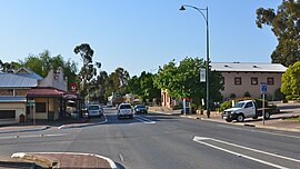
Queen Street, the main street of Williamstown
|
|||||||||||||
| Coordinates | 34°40′0″S 138°53′0″E / 34.66667°S 138.88333°ECoordinates: 34°40′0″S 138°53′0″E / 34.66667°S 138.88333°E | ||||||||||||
| Population | 1,432 (2006 census) | ||||||||||||
| Established | 1857 | ||||||||||||
| Postcode(s) | 5351 | ||||||||||||
| Elevation | 310 m (1,017 ft) | ||||||||||||
| Location | 51.7 km (32 mi) East of Adelaide via |
||||||||||||
| LGA(s) | Barossa Council | ||||||||||||
| State electorate(s) | Schubert | ||||||||||||
| Federal Division(s) | Mayo | ||||||||||||
|
|||||||||||||
|
|||||||||||||
Williamstown is a small South Australian village on the southern fringe of the Barossa Valley wine-growing region. It is 51 km north east of Adelaide and 16 km south-east of Gawler. Williamstown was originally known as Victoria Creek. The village was laid out in 1858 by Lewis Johnston, or Johnstone, on land he purchased in 1857, and named for his son.
The village has an elevation of 310m and an average rainfall of 680mm. It has a summer average temperature of 31 °C with temperatures often reaching mid 40's, and a winter average temperature of 15 °C, with nights dropping below freezing, which makes the region excellent for the cultivation of fruits, especially grapes in the lower riverine alluvial deposits.
Williamstown was essentially a farming area with sheep and cattle in the early days with fruit orchards, mixed farms and vines. The village also sustained a forestry and lumber industry from the earliest days with three sawmills. Today only a small family owned mill remains with the closure of the two larger mills by 1990. Many residents work in the wine / viticulture industry throughout the Barossa Valley.
In the Australian Federation Year a local hay barn found along Yettie Road (Yatta Creek Road) inhabited by ducks and pigeons was discovered to be the remains of the alleged oldest homestead in South Australia (circa 1821) which has been carefully restored to its former glory.
Springfield Homestead along Springton Road was originally the home of a local land baron pastoralist BJ McLaughlin who was a contemporary of the more famous Australian pastoral entrepreneurs and cattle barons. His great-great grandchildren still live at the historic Homestead. They still operate the fourth largest cattle station in Australia at Commonwealth Hill.
The nearby Barossa, Para Wirra and South Para Reservoirs were built in the early 1950s to help supply Adelaide with their demanding domestic water supplies. The Whispering Wall public attraction at the Barossa Reservoir is the colloquial name given to the curved dam retaining structure where nearby evidence of former small operation gold mining exists from the 1840s as evidenced by the local name of Kalamazoo Homestead. A handful of 'boutique' tourist gold mining operation were started around 1985 onwards near Sandy Creek and West of the reservoir aptly named the Barossa Goldfields. In recent decades numerous tourist accommodation and gastronomical ventures have been established to service the growing Barossa Valley wine tour industry, such as boutique businesses Linfield Road Wines / Cottage and Te-Aro Estate Wines.
...
Wikipedia

