Barossa Council
|
Barossa District Council South Australia |
|||||||||||||
|---|---|---|---|---|---|---|---|---|---|---|---|---|---|

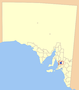
Location of the Barossa Council in blue
|
|||||||||||||
| Population | 23,104 (2015 est) | ||||||||||||
| • Density | 25.333/km2 (65.61/sq mi) | ||||||||||||
| Established | 1996 | ||||||||||||
| Area | 912 km2 (352.1 sq mi) | ||||||||||||
| Mayor | Bob Sloane | ||||||||||||
| Council seat | Angaston | ||||||||||||
| Region | Barossa, Light and Lower North | ||||||||||||
| State electorate(s) | Schubert | ||||||||||||
| Federal Division(s) | Wakefield | ||||||||||||
 |
|||||||||||||
| Website | Barossa District Council | ||||||||||||
|
|||||||||||||
Barossa Council is a local government area in the Barossa Valley in South Australia. The council area covers 912 square kilometres and has a population of 23,104.
It was proclaimed on 1 July 1996 following the amalgamation of the District Council of Angaston, the District Council of Barossa and the District Council of Tanunda. It also gained a portion of the former District Council of Mount Pleasant on 1 July 1997.
Townships in the council area include
Coordinates: 34°30′S 139°03′E / 34.500°S 139.050°E
...
Wikipedia
