Lyndoch, South Australia
|
Lyndoch South Australia |
|||||||||||||
|---|---|---|---|---|---|---|---|---|---|---|---|---|---|

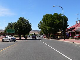
Main street of Lyndoch
|
|||||||||||||
| Coordinates | 34°36′04″S 138°53′28″E / 34.601°S 138.891°ECoordinates: 34°36′04″S 138°53′28″E / 34.601°S 138.891°E | ||||||||||||
| Population | 1,415 (2006 census) | ||||||||||||
| Established | 1837 | ||||||||||||
| Postcode(s) | 5351 | ||||||||||||
| Elevation | 175 m (574 ft) | ||||||||||||
| Location | 58 km (36 mi) North East of Adelaide via |
||||||||||||
| LGA(s) | Barossa Council | ||||||||||||
| Region | Barossa Valley | ||||||||||||
| State electorate(s) | Schubert | ||||||||||||
| Federal Division(s) | Barker | ||||||||||||
|
|||||||||||||
Lyndoch (34°36′S 138°53′E / 34.600°S 138.883°E) is a town in Barossa Valley, located on the Barossa Valley Highway between Gawler and Tanunda, 58 km northeast of Adelaide. The town has an elevation of 175m and an average rainfall of 560.5mm. It is one of the oldest towns in South Australia.
The town is now primarily a service centre for the surrounding grape and wine industry and a dormitory town with a significant number of local residents commuting to the city of Adelaide each day for employment.
Lyndoch is in the Barossa Council. It is in the state electoral district of Schubert and the federal Division of Barker.
Lyndoch was named by Colonel William Light in December 1837 after his esteemed friend Lord Lynedoch who was his captain in the Battle of Barrosa in 1811. It was an unfortunate misspelling that gave the town its name. The town was settled in 1839 and the village laid out later.
...
Wikipedia

