Williamston, South Carolina
| Williamston, South Carolina | |
|---|---|
| Town | |

Top, left to right: Downtown Williamston, the grave of West Allen William (founder of Williamston) in Williamston Springs Mineral Park, water tower at the Williamston Mill, Williamston Municipal Center
|
|
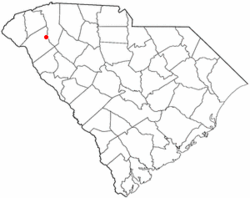
 Location of Williamston, South Carolina |
|
| Coordinates: 34°37′4″N 82°28′45″W / 34.61778°N 82.47917°WCoordinates: 34°37′4″N 82°28′45″W / 34.61778°N 82.47917°W | |
| Country | United States |
| State | South Carolina |
| County | Anderson |
| Area | |
| • Total | 3.7 sq mi (9.5 km2) |
| • Land | 3.6 sq mi (9.4 km2) |
| • Water | 0.04 sq mi (0.1 km2) |
| Elevation | 814 ft (248 m) |
| Population (2010) | |
| • Total | 3,934 |
| • Density | 1,080/sq mi (417.1/km2) |
| Time zone | Eastern (EST) (UTC-5) |
| • Summer (DST) | EDT (UTC-4) |
| ZIP code | 29697 |
| Area code(s) | 864 |
| FIPS code | 45-77875 |
| GNIS feature ID | 1251452 |
| Website | www |
Williamston is a town in Anderson County, South Carolina, United States, The population was 3,934 at the 2010 census.
Williamston is located in northeastern Anderson County at 34°37′4″N 82°28′45″W / 34.61778°N 82.47917°W (34.617699, -82.479256). The twin towns of Pelzer and West Pelzer are 2 miles (3 km) to the north. Anderson, the county seat, is 15 miles (24 km) to the southwest.
According to the United States Census Bureau, the town has a total area of 3.7 square miles (9.5 km2), of which 3.6 square miles (9.4 km2) is land and 0.04 square miles (0.1 km2), or 1.01%, is water.
As of the census of 2000, there were 3,791 people, 1,590 households, and 1,090 families residing in the town. The population density was 1,056.2 people per square mile (407.7/km²). There were 1,762 housing units at an average density of 490.9 per square mile (189.5/km²). The racial makeup of the town was 80.80% White, 17.67% African American, 0.08% Native American, 0.11% Asian, 0.66% from other races, and 0.69% from two or more races. Hispanic or Latino of any race were 1.74% of the population.
...
Wikipedia
