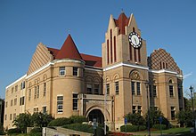
Wilkes County, Georgia
| Wilkes County, Georgia | |
|---|---|

|
|
 Location in the U.S. state of Georgia |
|
 Georgia's location in the U.S. |
|
| Founded | February 5, 1777 |
| Named for | John Wilkes |
| Seat | Washington |
| Largest city | Washington |
| Area | |
| • Total | 474 sq mi (1,228 km2) |
| • Land | 469 sq mi (1,215 km2) |
| • Water | 4.6 sq mi (12 km2), 1.0% |
| Population | |
| • (2010) | 10,593 |
| • Density | 23/sq mi (9/km²) |
| Congressional district | 10th |
| Time zone | Eastern: UTC-5/-4 |
| Website | www |
Wilkes County is a county located in the east central portion of the U.S. state of Georgia. As of the 2010 census, the population was 10,593. The county seat is the city of Washington.
Referred to as "Washington-Wilkes", the county seat and county are commonly treated as a single entity by locals, including the area's historical society and the Chamber of Commerce. It is part of the Central Savannah River Area (CSRA).
Wilkes County, named for British politician and supporter of American independence, John Wilkes, is considered Georgia's first county established by European Americans; it was the first of eight original counties created in the first state constitution on February 5, 1777. The other seven counties were organized from existing colonial parishes.
Wilkes was unique in being land ceded in 1773 by the Creek and Cherokee nations in their respective Treaties of Augusta. It is located in the Piedmont above the fall line on the Savannah River.
Between 1790 and 1854, Wilkes County's area was reduced as it was divided to organize new counties as population increased in the area. The Georgia legislature formed the counties of Elbert, Oglethorpe, and Lincoln entirely from portions of Wilkes County. Wilkes also contributed part of the lands used in the creation of Madison, Warren, Taliaferro, Hart, McDuffie, and Greene Counties.
...
Wikipedia
