Warren County, Georgia
| Warren County, Georgia | |
|---|---|

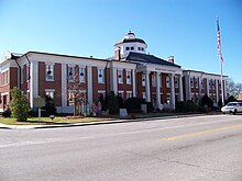
Warren County courthouse in Warrenton
|
|
 Location in the U.S. state of Georgia |
|
 Georgia's location in the U.S. |
|
| Founded | December 19, 1793 |
| Named for | Joseph Warren |
| Seat | Warrenton |
| Largest city | Warrenton |
| Area | |
| • Total | 287 sq mi (743 km2) |
| • Land | 284 sq mi (736 km2) |
| • Water | 2.4 sq mi (6 km2), 0.8% |
| Population | |
| • (2010) | 5,834 |
| • Density | 21/sq mi (8/km²) |
| Congressional district | 10th |
| Time zone | Eastern: UTC-5/-4 |
| Website | www |
Warren County is a county located in the U.S. state of Georgia. As of the 2010 census, the population was 5,834. The county seat is Warrenton. The county was created on December 19, 1793 and is named after General Joseph Warren, who was killed in the Battle of Bunker Hill.
According to the U.S. Census Bureau, the county has a total area of 287 square miles (740 km2), of which 284 square miles (740 km2) is land and 2.4 square miles (6.2 km2) (0.8%) is water.
The north-to-northeastern quarter of Warren County, north of a line between the county's northwestern corner, Norwood, and Camak, is located in the Little River sub-basin of the Savannah River basin. The southeastern quarter, from Camak in the north, and bordered by a northwest-to-southeast line running through Warrenton, is located in the Brier Creek sub-basin of the larger Savannah River basin. The western half of the county, west of Warrenton, is located in the Upper Ogeechee River sub-basin of the Ogeechee River basin.
As of the census of 2000, there were 6,336 people, 2,435 households, and 1,692 families residing in the county. The population density was 22 people per square mile (9/km²). There were 2,767 housing units at an average density of 10 per square mile (4/km²). The racial makeup of the county was 39.46% White, 59.47% Black or African American, 0.17% Native American, 0.14% Asian, 0.30% from other races, and 0.46% from two or more races. 0.80% of the population were Hispanic or Latino of any race.
...
Wikipedia
