Wicklow Mountains National Park
| Wicklow Mountains National Park | |
|---|---|
|
IUCN category II (national park)
|
|

Cloghernagh Mountain
|
|

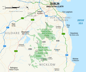
Map showing park and surrounding areas
|
|
| Location | County Wicklow, Ireland |
| Nearest city | Dublin |
| Coordinates | 53°01′05″N 6°23′53″W / 53.018°N 6.398°WCoordinates: 53°01′05″N 6°23′53″W / 53.018°N 6.398°W |
| Area | 220 square kilometres (54,000 acres) |
| Established | 1991 |
| Governing body | NPWS National Parks and Wildlife Service |
Department of Arts, Heritage, Regional, Rural and Gaeltacht Affairs
Wicklow Mountains National Park (Irish: Páirc Náisiúnta Sléibhte Chill Mhantáin) is a 220-square-kilometre (54,000-acre) protected area in Ireland, one of six national parks in the country. The park stretches through County Wicklow as well as small areas of South Dublin and Dún Laoghaire–Rathdown in County Dublin. The park is located in the Wicklow Mountains a short distance south of Dublin. It contains a variety of attractions that are popular with city dwellers seeking recreation, and areas visited by tourists and history enthusiasts.
Chief among the historic sites is Glendalough, which features a collection of Early Medieval monastic structures associated with St Kevin, a hermit priest. Other sites include the Education Centre in Bolger's Cottage, on the Miners' Road by the Upper Lake, Glendalough, and remnants of mining villages.
Recreational activities available within the park include walking and hiking, rock climbing, rowing, diving, limited swimming and fishing, and many opportunities for sightseeing and photography. Motor tourists may take the R756 road which passes through the Wicklow Gap. Another scenic driving route follows the historic Military Road designated R115 from the Dublin Hills south through the centre of the mountains to Laragh village.
...
Wikipedia
