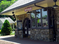
Whitehouse Station, New Jersey
| Whitehouse Station, New Jersey | |
|---|---|
| Census-designated place | |

Whitehouse Train Station & Readington Library
|
|
 Map of Whitehouse Station highlighted within Hunterdon County. Right: Location of Hunterdon County in New Jersey. |
|
| Coordinates: 40°36′58″N 74°46′19″W / 40.616169°N 74.771893°WCoordinates: 40°36′58″N 74°46′19″W / 40.616169°N 74.771893°W | |
| Country |
|
| State |
|
| County | Hunterdon |
| Township | Readington |
| Area | |
| • Total | 1.346 sq mi (3.487 km2) |
| • Land | 1.303 sq mi (3.376 km2) |
| • Water | 0.043 sq mi (0.111 km2) 3.20% |
| Elevation | 174 ft (53 m) |
| Population (2010 Census) | |
| • Total | 2,089 |
| • Density | 1,602.7/sq mi (618.8/km2) |
| Time zone | Eastern (EST) (UTC-5) |
| • Summer (DST) | Eastern (EDT) (UTC-4) |
| ZIP code | 08889 |
| Area code(s) | 908 |
| FIPS code | 3480720 |
| GNIS feature ID | 02390505 |
Whitehouse Station is an unincorporated community and census-designated place (CDP) located within Readington Township, in Hunterdon County, New Jersey, United States. At the 2010 United States Census, the CDP's population was 2,089. Whitehouse Station takes its name from Whitehouse and Abraham Van Horne's 18th century tavern.
New Jersey Transit offers service on the Raritan Valley Line at White House Station.
The area, which is now served only by New Jersey Transit's Raritan Valley Line, used to be a railroad junction, serving as the endpoint of the ill-fated Rockaway Valley Railroad, which ceased operation in 1913. Whitehouse Station was home to the global headquarters of pharmaceutical giant Merck, which was housed in the modernist Merck Headquarters Building. Merck is in the process of moving out of the campus, shifting its base of operations to Kenilworth.
According to the United States Census Bureau, the CDP had a total area of 1.346 square miles (3.487 km2), including 1.303 square miles (3.376 km2) of land and 0.043 square miles (0.111 km2) of water (3.20%).
The 2010 United States Census counted 2,089 people, 963 households, and 552.8 families residing in the CDP. The population density was 1,602.7 per square mile (618.8/km2). The CDP contained 989 housing units at an average density of 758.8 per square mile (293.0/km2). The racial makeup of the CDP was 91.53% (1,912) White, 2.82% (59) Black or African American, 0.05% (1) Native American, 3.06% (64) Asian, 0.00% (0) Pacific Islander, 1.15% (24) from other races, and 1.39% (29) from two or more races. Hispanics or Latinos of any race were 5.27% (110) of the population.
...
Wikipedia
