White Rock, South Dakota
| White Rock, South Dakota | |
|---|---|
| Town | |
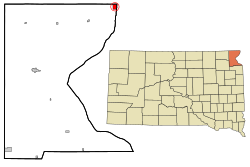
 Location in Roberts County and the state of South Dakota |
|
| Coordinates: 45°55′9″N 96°34′22″W / 45.91917°N 96.57278°WCoordinates: 45°55′9″N 96°34′22″W / 45.91917°N 96.57278°W | |
| Country | United States |
| State | South Dakota |
| County | Roberts |
| Area | |
| • Total | 1.57 sq mi (4.07 km2) |
| • Land | 1.57 sq mi (4.07 km2) |
| • Water | 0 sq mi (0 km2) |
| Elevation | 974 ft (297 m) |
| Population (2010) | |
| • Total | 3 |
| • Estimate (2013) | 3 |
| • Density | 1.9/sq mi (0.7/km2) |
| Time zone | Central (CST) (UTC-6) |
| • Summer (DST) | CDT (UTC-5) |
| Area code(s) | 605 |
| FIPS code | 46-71380 |
| GNIS feature ID | 1258972 |
White Rock is a town in Roberts County, South Dakota, United States, along the Bois de Sioux River. The population was 3 at the 2010 census. White Rock is the most northeastern community in South Dakota, being along the Minnesota border and one mile south of North Dakota.
A post office called White Rock was established in 1885, and remained in operation until 1965. White Rock took its name from a white granite boulder near the original town site. The namesake boulder was destroyed and a grain elevator was built at the spot.
White Rock is located at 45°55′9″N 96°34′22″W / 45.91917°N 96.57278°W (45.919046, -96.572776).
According to the United States Census Bureau, the town has a total area of 1.57 square miles (4.07 km2), all of it land.
As of the census of 2010, there were 3 people, 3 households, and 0 families residing in the town. The population density was 1.9 inhabitants per square mile (0.7/km2). There were 8 housing units at an average density of 5.1 per square mile (2.0/km2). The racial makeup of the town was 33.3% White, 33.3% Native American, and 33.3% from other races. Hispanic or Latino of any race were 33.3% of the population.
...
Wikipedia
