White Oak, Ohio
| White Oak, Ohio | |
|---|---|
| Census-designated place | |

White Oak Commercial Area
|
|
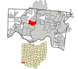
 Location in Hamilton County and the state of Ohio. |
|
| Coordinates: 39°12′50″N 84°35′49″W / 39.21389°N 84.59694°WCoordinates: 39°12′50″N 84°35′49″W / 39.21389°N 84.59694°W | |
| Country | United States |
| State | Ohio |
| County | Hamilton |
| Area | |
| • Total | 6.2 sq mi (16.0 km2) |
| • Land | 6.2 sq mi (16.0 km2) |
| • Water | 0.0 sq mi (0.0 km2) |
| Elevation | 915 ft (279 m) |
| Population (2010) | |
| • Total | 19,167 |
| • Density | 3,100/sq mi (1,200/km2) |
| Time zone | Eastern (EST) (UTC-5) |
| • Summer (DST) | EDT (UTC-4) |
| ZIP codes | 45239, 45247 |
| Area code(s) | 513 |
| FIPS code | 39-84812 |
| GNIS feature ID | 1056570 |
White Oak is a census-designated place (CDP) in Hamilton County, Ohio, United States. It is seven miles northwest of Cincinnati. The population was 19,167 at the 2010 census.
White Oak was originally known as Saint Jacobs in the 19th century.
White Oak is located at 39°12′50″N 84°35′49″W / 39.21389°N 84.59694°W (39.213993, -84.596903).
According to the United States Census Bureau, the CDP has a total area of 6.2 square miles (16.0 km2), all land.
As of the census of 2000, there were 13,277 people, 5,263 households, and 3,647 families residing in the CDP. The population density was 3,242.7 people per square mile (1,253.4/km²). There were 5,464 housing units at an average density of 1,334.5/sq mi (515.8/km²). The racial makeup of the CDP was 93.88% White, 3.55% African American, 0.17% Native American, 1.09% Asian, 0.41% from other races, and 0.91% from two or more races. Hispanic or Latino of any race were 1.08% of the population.
...
Wikipedia
