Whatcom County
| Whatcom County, Washington | ||
|---|---|---|

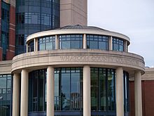
Whatcom County Courthouse in Bellingham
|
||
|
||
 Location in the U.S. state of Washington |
||
 Washington's location in the U.S. |
||
| Founded | March 9, 1854 | |
| Seat | Bellingham | |
| Largest city | Bellingham | |
| Area | ||
| • Total | 2,503 sq mi (6,483 km2) | |
| • Land | 2,107 sq mi (5,457 km2) | |
| • Water | 397 sq mi (1,028 km2), 16% | |
| Population (est.) | ||
| • (2015) | 212,284 | |
| • Density | 99/sq mi (38/km²) | |
| Congressional districts | 1st, 2nd | |
| Time zone | Pacific: UTC-8/-7 | |
| Website | www |
|
Whatcom County /ˈhwɒtkəm/ is a county located in the U.S. state of Washington. As of the 2010 census, the population was 201,140. It is bordered by Canada on the north, Okanogan County on the east, Skagit County on the south, and the Strait of Georgia on the west. The county seat and largest city is Bellingham.
The county was created from Island County by the Washington Territorial Legislature on March 9, 1854. It originally included the territory of present-day San Juan and Skagit counties, which were later organized after additional settlement. Its name derives from the Lummi word Xwotʼqom, meaning "noisy water."
Whatcom County comprises the Bellingham, WA Metropolitan Statistical Area.
Whatcom County's northern border is the Canada–US border with the Canadian province of British Columbia. Adjoining the county on the north are five of metropolitan Vancouver's suburbs, Delta, White Rock, Surrey, Langley, and, in the central Fraser Valley, Abbotsford.
...
Wikipedia

