Westville, New Jersey
| Westville, New Jersey | |
|---|---|
| Borough | |
| Borough of Westville | |
| Motto: "The Gateway to South Jersey" | |
 Map of Westville highlighted within Gloucester County. Inset: Location of Gloucester County in New Jersey. |
|
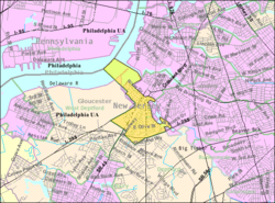
 Census Bureau map of Westville, New Jersey |
|
| Coordinates: 39°52′08″N 75°07′54″W / 39.868922°N 75.131584°WCoordinates: 39°52′08″N 75°07′54″W / 39.868922°N 75.131584°W | |
| Country | |
| State |
|
| County |
|
| Incorporated | April 28, 1914 |
| Government | |
| • Type | Borough |
| • Body | Borough Council |
| • Mayor | Russell W. Welsh Jr. (D, term ends December 31, 2018) |
| • Administrator | William J. Bittner Jr. |
| • Clerk | Christine A. Helder |
| Area | |
| • Total | 1.378 sq mi (3.568 km2) |
| • Land | 1.024 sq mi (2.652 km2) |
| • Water | 0.354 sq mi (0.916 km2) 25.66% |
| Area rank | 463rd of 566 in state 21st of 24 in county |
| Elevation | 23 ft (7 m) |
| Population (2010 Census) | |
| • Total | 4,288 |
| • Estimate (2015) | 4,224 |
| • Rank | 400th of 566 in state 17th of 24 in county |
| • Density | 4,187.0/sq mi (1,616.6/km2) |
| • Density rank | 143rd of 566 in state 2nd of 24 in county |
| Time zone | Eastern (EST) (UTC−5) |
| • Summer (DST) | Eastern (EDT) (UTC−4) |
| ZIP code | 08093 |
| Area code | 856 |
| FIPS code | 3401580120 |
| GNIS feature ID | 0885440 |
| Website | www |
Westville is a borough in Gloucester County, New Jersey, United States. As of the 2010 United States Census, the borough's population was 4,288, reflecting a decline of 212 (-4.7%) from the 4,500 counted in the 2000 Census, which had in turn declined by 73 (-1.6%) from the 4,573 counted in the 1990 Census. The Borough of Westville is known as "The Gateway to South Jersey!"
Westville was formed as a borough by an act of the New Jersey Legislature on April 7, 1914, from portions of Deptford Township and West Deptford Township, based on the results of a referendum held on April 28, 1914. The borough was reincorporated on March 8, 1924. Legislation had been passed in 1900 to create Westville, but it had to have a majority vote in favor of the new municipality in both Deptford and West Deptford. The borough was named for Thomas West, who built a home in the area in 1775 that still stands.
According to the United States Census Bureau, the borough had a total area of 1.378 square miles (3.568 km2), including 1.024 square miles (2.652 km2) of land and 0.354 square miles (0.916 km2) of water (25.66%).
Unincorporated communities, localities and place names located partially or completely within the borough include Newbold, South Westville, Business District, Victoria, and Gardner Tract. .
The borough borders Deptford Township, West Deptford Township, and Camden County.
The 2010 United States Census counted 4,288 people, 1,755 households, and 1,095 families residing in the borough. The population density was 4,187.0 per square mile (1,616.6/km2). The borough contained 1,912 housing units at an average density of 1,867.0 per square mile (720.9/km2). The racial makeup of the borough was 89.53% (3,839) White, 4.90% (210) Black or African American, 0.16% (7) Native American, 1.49% (64) Asian, 0.05% (2) Pacific Islander, 2.31% (99) from other races, and 1.56% (67) from two or more races. Hispanics or Latinos of any race were 6.02% (258) of the population.
...
Wikipedia
