Weston, Toronto
| Weston | |
|---|---|
| Neighbourhood | |

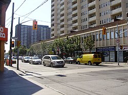
Weston Road at John
|
|
 |
|
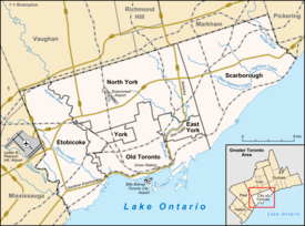
| Location within Toronto | |
| Coordinates: 43°42′3.56″N 79°31′10.92″W / 43.7009889°N 79.5197000°WCoordinates: 43°42′3.56″N 79°31′10.92″W / 43.7009889°N 79.5197000°W | |
| Country |
|
| Province |
|
| City |
|
| Community | York |
| Settled | c. 1790s |
| Incorporated | 1881 (Village) 1914 (Town) |
| Changed Municipality | 1954 1998 Toronto from York |
| Annexed | 1967 into York |
| Government | |
| • MP | Ahmed Hussen (York South—Weston) |
| • MPP | Laura Albanese (York South—Weston) |
| • Councillor | Frances Nunziata (Ward 11 York South-Weston) |
| Population (2006) | |
| • Total | 16,470 |
| Website | welcometoweston.ca |
Weston is a neighbourhood and former village in Toronto, Ontario, Canada. The neighbourhood is situated in the northwest of the city, south of Highway 401, east of the Humber River, north of Eglinton Avenue, and west of Jane Street.Weston Road just north of Lawrence Avenue is the commercial core of Weston, with many small businesses and services. Weston was incorporated as a village in the 19th century and was absorbed into the Borough of York in the late 1960s. York itself was amalgamated into Toronto in 1998.
Weston's building stock consists mostly of Victorian homes east of the railway with apartment and condominium towers on Weston Road overlooking the Humber River valley. Weston's main shopping district is located on Weston Road between Church Street in the north and Wilby Crescent (just south of Lawrence Avenue) in the south. Most buildings in this area reflect early-mid-20th century Ontario town architecture, brick buildings with decorative masonry. The area has a noteworthy library (previously a Mechanics' Institute and Carnegie library). The community is dotted with grand old churches with architectural significance. There has been a recent move in Weston to designate certain areas as a historical district. Most streets in Weston are lined with tall mature trees, some well over 100 years old. This is more common east of the railway tracks. Recently, there has been some infill development on former industrial and commercial lands bringing some new housing stock to the area. On April 26, 2013, a fire was accidentally started at 2304 Weston Road, due to tar during roof construction.
The Weston Farmers' Market opens weekly from mid-May to the end of October near the centre of Weston. The Weston BIA also hosts a Harvest Festival around Thanksgiving in October, and the Weston Santa Claus Parade each November.
Weston has many small parks throughout but most notable is Cruickshank Park in the Humber River valley with many mature trees and paved bicycle paths lined with large weeping willow trees. The bicycle path continues south to Lake Ontario. Sometimes salmon can be seen swimming upstream in the river. The park has a population of beaver as can be seen from the tell-tale marks left behind on trees. In order to protect some trees, park staff have wrapped the tree trunks with wire screen in some areas. There are also some frogs closer to the water's edge and garter snakes hidden away in the more secluded areas. Canada geese, loons, mallards and seagulls are a common sight. Herons have also been spotted looking for fish in the river. In some areas of the park, you can see exposed sedimentary rock in the walls of the valley, made visible by the action of glaciers that carved out the valley during the last glacial period about 20,000 years ago. The same rock was used to build many stone retaining walls throughout the town; an example of this use can be seen on the south end of the Lawrence Avenue bridge in the north end of Lions Park.
...
Wikipedia

