Westhampton, New York
| Westhampton, New York | |
|---|---|
| Hamlet and census-designated place | |

Inland waterway in Westhampton
|
|
 |
|
| Coordinates: 40°49′22″N 72°39′52″W / 40.82278°N 72.66444°WCoordinates: 40°49′22″N 72°39′52″W / 40.82278°N 72.66444°W | |
| Country | United States |
| State | New York |
| County | Suffolk |
| Area | |
| • Total | 14.9 sq mi (38.5 km2) |
| • Land | 12.7 sq mi (32.8 km2) |
| • Water | 2.2 sq mi (5.7 km2) |
| Elevation | 36 ft (11 m) |
| Population (2010) | |
| • Total | 3,079 |
| • Density | 210/sq mi (80/km2) |
| Time zone | Eastern (EST) (UTC-5) |
| • Summer (DST) | EDT (UTC-4) |
| ZIP code | 11977 |
| Area code(s) | 631 |
| FIPS code | 36-80170 |
| GNIS feature ID | 0970920 |
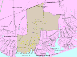
Westhampton is a hamlet and census-designated place (CDP) in Suffolk County, New York, United States. The population was 3,079 at the 2010 census.
Westhampton is in the Town of Southampton.
Westhampton is located at 40°49′22″N 72°39′52″W / 40.82278°N 72.66444°W (40.822894, -72.664306).
According to the United States Census Bureau, the CDP has a total area of 14.9 square miles (38.5 km2), of which 12.7 square miles (32.8 km2) is land and 2.2 square miles (5.7 km2), or 14.74%, is water.
Westhampton has an oceanic climate (Cfd) under the Köppen climate classification, with moderately cold winters and warm summers. Westhampton sees an average of 43.4 inches of precipitation per year.
As of the census of 2000, there were 2,869 people, 1,070 households, and 766 families residing in the CDP. The population density was 326.2 per square mile (125.9/km²). There were 1,601 housing units at an average density of 182.0/sq mi (70.2/km²). The racial makeup of the CDP was 91.04% White, 4.43% African American, 0.28% Native American, 1.25% Asian, 0.80% from other races, and 2.20% from two or more races. Hispanic or Latino of any race were 5.47% of the population.
...
Wikipedia

