Westfield, New Jersey
| Westfield, New Jersey | |
|---|---|
| Town | |

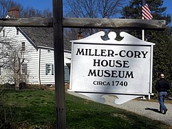
Miller-Cory House Museum
|
|
 Map of Westfield in Union County. Inset: Location of Union County highlighted in the State of New Jersey. |
|
 Census Bureau map of Westfield, New Jersey |
|
| Coordinates: 40°39′06″N 74°20′36″W / 40.651644°N 74.343447°WCoordinates: 40°39′06″N 74°20′36″W / 40.651644°N 74.343447°W | |
| Country |
|
| State |
|
| County | Union |
| Formed | January 27, 1794 |
| Incorporated | February 21, 1798, as township |
| Reincorporated | March 4, 1903, as town |
| Government | |
| • Type | Special Charter |
| • Body | Town Council |
| • Mayor | Andrew Skibitsky (R, term ends December 31, 2017) |
| • Administrator | James H. Gildea |
| • Clerk | Claire J. Gray |
| Area | |
| • Total | 6.743 sq mi (17.463 km2) |
| • Land | 6.719 sq mi (17.401 km2) |
| • Water | 0.024 sq mi (0.062 km2) 0.36% |
| Area rank | 245th of 566 in state 5th of 21 in county |
| Elevation | 118 ft (36 m) |
| Population (2010 Census) | |
| • Total | 30,316 |
| • Estimate (2015) | 30,548 |
| • Rank | 74th of 566 in state 5th of 21 in county |
| • Density | 4,512.2/sq mi (1,742.2/km2) |
| • Density rank | 127th of 566 in state 12th of 21 in county |
| Time zone | Eastern (EST) (UTC-5) |
| • Summer (DST) | Eastern (EDT) (UTC-4) |
| ZIP codes | 07090-07091 |
| Area code(s) | 908 |
| FIPS code | 3403979040 |
| GNIS feature ID | 0885436 |
| Website | Official website |
Westfield is a town in Union County of New Jersey, United States. As of the 2010 United States Census, the town's population was 30,316, reflecting an increase of 672 (+2.3%) from the 29,644 counted in the 2000 Census, which had in turn increased by 774 (+2.7%) from the 28,870 counted in the 1990 Census. According to a 2014 nationwide survey, Westfield is considered to be the 30th-safest city to live in the United States.
The old village area, now the downtown district, was settled in 1720 as part of the Elizabethtown Tract. Westfield was originally formed as a township on January 27, 1794, from portions of Elizabeth Township, while the area was still part of Essex County, and was incorporated on February 21, 1798, as one of New Jersey's initial group of 104 townships by an act of the New Jersey Legislature. It became part of the newly formed Union County on March 19, 1857. Portions of the township have been taken to form Rahway Township (February 27, 1804), Plainfield Township (April 5, 1847), Cranford Township (March 14, 1871), Fanwood Township (March 6, 1878; now known as Scotch Plains) and Mountainside (September 25, 1895). The Town of Westfield was incorporated on March 4, 1903, replacing Westfield Township. The name of the town is derived from its location in the western, undeveloped fields of the Elizabethtown tract.
According to the United States Census Bureau, the town had a total area of 6.743 square miles (17.463 km2), including 6.719 square miles (17.401 km2) of land and 0.024 square miles (0.062 km2) of water (0.36%).
...
Wikipedia
