Mountainside, New Jersey
| Mountainside, New Jersey | |
|---|---|
| Borough | |
| Borough of Mountainside | |
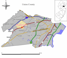
 Map of Mountainside in Union County. Inset: Union County highlighted in the State of New Jersey. |
|
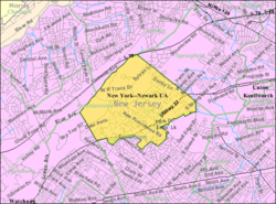
 Census Bureau map of Mountainside, New Jersey |
|
| Coordinates: 40°40′51″N 74°21′37″W / 40.680722°N 74.360292°WCoordinates: 40°40′51″N 74°21′37″W / 40.680722°N 74.360292°W | |
| Country |
|
| State |
|
| County | Union |
| Incorporated | September 25, 1895 |
| Government | |
| • Type | Faulkner Act (Mayor-Council) |
| • Body | Borough Council |
| • Mayor | Paul N. Mirabelli (R, term ends December 31, 2019) |
| • Administrator | James J. Debbie Jr. |
| • Clerk | Martha Lopez |
| Area | |
| • Total | 4.049 sq mi (10.487 km2) |
| • Land | 4.008 sq mi (10.380 km2) |
| • Water | 0.041 sq mi (0.107 km2) 1.02% |
| Area rank | 296th of 566 in state 12th of 21 in county |
| Elevation | 233 ft (71 m) |
| Population (2010 Census) | |
| • Total | 6,685 |
| • Estimate (2015) | 6,885 |
| • Rank | 324th of 566 in state 19th of 21 in county |
| • Density | 1,668.0/sq mi (644.0/km2) |
| • Density rank | 315th of 566 in state 21st of 21 in county |
| Time zone | Eastern (EST) (UTC-5) |
| • Summer (DST) | Eastern (EDT) (UTC-4) |
| ZIP code | 07092 |
| Area code(s) | 908 |
| FIPS code | 3403948510 |
| GNIS feature ID | 0885311 |
| Website | www |
Mountainside is a borough in Union County, New Jersey, United States. As of the 2010 United States Census, the borough's population was 6,685, reflecting an increase of 83 (+1.3%) from the 6,602 counted in the 2000 Census, which had in turn declined by 55 (-0.8%) from the 6,657 counted in the 1990 Census.
Mountainside was incorporated as a borough on September 25, 1895, from portions of Westfield Township, based on the results of a referendum held the previous day.
New Jersey Monthly magazine ranked Mountainside as its 16th best place to live in its 2008 rankings of the "Best Places To Live" in New Jersey, as well as eighth in the 2010 list.
In 1958, part of a Nike missile battery (NY-73) was installed, with the missile launchers themselves in Mountainside while the radar station was installed in Berkeley Heights. It remained in operation until 1963 and remnants of the site are located adjacent to Governor Livingston High School.
According to the United States Census Bureau, the borough had a total area of 4.0497 square miles (10.487 km2), including 4.008 square miles (10.380 km2) of land and 0.041 square miles (0.107 km2) of water (1.02%).
The borough is bordered to the north by Summit, to the east by Springfield Township, to the south by Westfield, and to the west by Berkeley Heights and Scotch Plains.
...
Wikipedia
