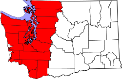
Western Washington
| Western Washington | |
| Region | |
| Country | United States |
|---|---|
| State | Washington |
| Part of | Pacific Northwest |
| Borders on | British Columbia, Western Oregon, Pacific Ocean, Cascade Range/Eastern Washington |
| Rivers | Columbia River, Chehalis River, Puget Sound watershed (numerous) |
| Coordinates | 47°30′N 122°0′W / 47.500°N 122.000°WCoordinates: 47°30′N 122°0′W / 47.500°N 122.000°W |
Western Washington is a region of the United States defined as that part of Washington west of the Cascade Mountains. This region is home to the state's largest city, Seattle, and the majority of the state's residents. The climate is generally far more damp and temperate than Eastern Washington.
It is known as being far wetter in climate than the eastern portion of the state, which is due in main to the effects of the Cascades rain shadow. The average place in Eastern Washington only receives an average of 46.87 centimeters (18.45 inches) of precipitation per year. However, the average place in Western Washington receives an average of 167.72 centimeters (66.03 inches) of precipitation per year. The average place in Western Washington gets 168 days of measurable precipitation per year. The place that receives the most recorded precipitation is Lake Quinault on the Olympic Peninsula with an average of 332.92 centimeters (131.07 inches) per year. The place that gets the most days of measurable precipitation is the Long Beach Experimental Station with an average of 215 days of measurable precipitation per year.
In the 2010 census, Western Washington had a population of 5,229,486 out of the 6,724,540 in the entire state of Washington. This makes the population comparable to that of Minnesota with a population of 5,303,925. It has a land area of 24,742 square miles (64,080 km2), for a population density of 211.36 people per square mile (81.61 people per square kilometer).
Counties in Western Washington:
Major cities in Western Washington:
...
Wikipedia

