Chehalis River (Washington)
| Chehalis River | |
| River | |
|
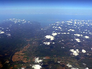
Chehalis River Valley (left), Grays Harbor (middle distance) and Satsop River Valley (along bottom)
|
|
| Country | United States |
|---|---|
| State | Washington |
| Counties | Grays Harbor, Thurston, Lewis |
| Tributaries | |
| - right | South Fork Chehalis River, Newaukum River, Skookumchuck River, Satsop River, Wynoochee River, Wishkah River |
| Cities | Aberdeen, Centralia, Chehalis |
| Source | |
| - elevation | 1,000 ft (305 m) |
| - coordinates | 46°27′6″N 123°17′30″W / 46.45167°N 123.29167°W |
| Mouth | Pacific Ocean |
| - location | Grays Harbor, Aberdeen |
| - elevation | 0 ft (0 m) |
| - coordinates | 46°57′29″N 123°50′5″W / 46.95806°N 123.83472°WCoordinates: 46°57′29″N 123°50′5″W / 46.95806°N 123.83472°W |
| Length | 115 mi (185 km) |
| Basin | 2,660 sq mi (6,889 km2) |
| Discharge | for near Satsop, WA |
| - average | 6,425 cu ft/s (182 m3/s) |
| - max | 47,000 cu ft/s (1,331 m3/s) |
| - min | 440 cu ft/s (12 m3/s) |
|
Map of the Chehalis River watershed
|
|
The Chehalis River (/ʃəˈheɪlᵻs/ shə-HAY-lis) is a river in Washington in the United States. It originates in several forks in southwestern Washington, flows east, then north, then west, in a large curve, before emptying into Grays Harbor, an estuary of the Pacific Ocean.
The Chehalis River begins at the confluence of the West Fork Chehalis River and East Fork Chehalis River, in southwestern Lewis County. From there the Chehalis flows north and east, collecting tributary streams that drain the Willapa Hills and other low mountains of southwestern Washington. The South Fork Chehalis River joins the main river a few miles west of the city of Chehalis. The Newaukum River joins the Chehalis River at Chehalis, after which the river turns north, flowing by the city of Centralia, where the Skookumchuck River joins. After Centralia, the Chehalis River flows north and west, collecting tributaries such as the Black River, which drains the Black Hills to the north, then in the Chehalis Gap collects the Satsop River and Wynoochee River, which drain the southern part of the Olympic Mountains.
...
Wikipedia


